IMAGES TAKEN NEAR TO
HAWICK, TD9 9TB
Introduction
This page details the photographs taken nearby to TD9 9TB by members of the Geograph project.
The Geograph project started in 2005 with the aim of publishing, organising and preserving representative images for every square kilometre of Great Britain, Ireland and the Isle of Man.

There are currently over 7.5m images from over14,400 individuals and you can help contribute to the project by visiting https://www.geograph.org.uk
Image Map
Images are licensed for reuse under creativecommons.org/licenses/by-sa/2.0
Notes
- Clicking on the map will re-center to the selected point.
- The higher the marker number, the further away the image location is from the centre of the postcode.
Image Listing (8 Images Found)
Images are licensed for reuse under creativecommons.org/licenses/by-sa/2.0
Image
Details
Distance
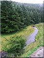
3
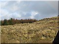
Pile of roadstone, Hyndlee Glen
Awaiting pothole filling duty somewhere in Wauchope Forest. Always a dilemma for the orienteering mapper - will the piles be used or will they stay around a while and need to go on the map.
Image: © Richard Webb
Taken: 28 Sep 2009
0.14 miles
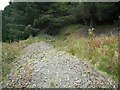
4
High-tech premises for blue tits
On a tree by the forestry road at Hyndlee.
Image: © Walter Baxter
Taken: 19 Aug 2007
0.15 miles
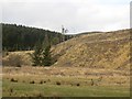
7
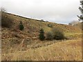
Clear felled slope, Hyndlee
Wauchope Forest seen from the Bonchester Bridge to Newcastleton road.
Image: © Richard Webb
Taken: 16 Mar 2014
0.20 miles
8
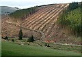
Timber harvesting on Brockie Law
This was viewed from the B6357.
Image: © Walter Baxter
Taken: 2 May 2012
0.21 miles