IMAGES TAKEN NEAR TO
HAWICK, TD9 9SX
Introduction
This page details the photographs taken nearby to TD9 9SX by members of the Geograph project.
The Geograph project started in 2005 with the aim of publishing, organising and preserving representative images for every square kilometre of Great Britain, Ireland and the Isle of Man.

There are currently over 7.5m images from over14,400 individuals and you can help contribute to the project by visiting https://www.geograph.org.uk
Image Map
Images are licensed for reuse under creativecommons.org/licenses/by-sa/2.0
Notes
- Clicking on the map will re-center to the selected point.
- The higher the marker number, the further away the image location is from the centre of the postcode.
Image Listing (7 Images Found)
Images are licensed for reuse under creativecommons.org/licenses/by-sa/2.0
Image
Details
Distance
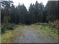
1
Crown Plantation
Path running into Crown Plantation.
Image: © Richard Webb
Taken: 16 Mar 2014
0.09 miles
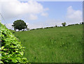
2
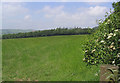
Summer pasture
A lush field near Cleuch Head.
Image: © Walter Baxter
Taken: 9 Jun 2007
0.10 miles
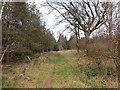
4
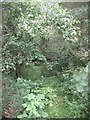
Crown Wood
Borders Forest Trust, best known for their Carrifran project are also busy keeping other parts of Southern Scotland wooded with appropriate trees.
http://www.bordersforesttrust.org/
This is looking down a very overgrown path into the wood - too wet for deeper exploration today.
Image: © Richard Webb
Taken: 1 Aug 2008
0.18 miles
5
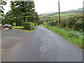
Road passing through Cleuch Head
Looking south-westward.
Image: © Peter Wood
Taken: 13 Oct 2015
0.22 miles
6
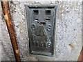
Ordnance Survey Flush Bracket 11418
This can be found on the wall of a private dwelling at Cleuch Head.
For more detail see : http://www.bench-marks.org.uk/bm16609
Image: © Peter Wood
Taken: 13 Oct 2015
0.22 miles