IMAGES TAKEN NEAR TO
HAWICK, TD9 9SF
Introduction
This page details the photographs taken nearby to TD9 9SF by members of the Geograph project.
The Geograph project started in 2005 with the aim of publishing, organising and preserving representative images for every square kilometre of Great Britain, Ireland and the Isle of Man.

There are currently over 7.5m images from over14,400 individuals and you can help contribute to the project by visiting https://www.geograph.org.uk
Image Map
Images are licensed for reuse under creativecommons.org/licenses/by-sa/2.0
Notes
- Clicking on the map will re-center to the selected point.
- The higher the marker number, the further away the image location is from the centre of the postcode.
Image Listing (4 Images Found)
Images are licensed for reuse under creativecommons.org/licenses/by-sa/2.0
Image
Details
Distance
1
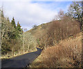
The B6339 near Stobs Castle
Looking towards Denholm Hill with Cogsmill Wood on the left.
Image: © Walter Baxter
Taken: 2 Mar 2007
0.07 miles
2
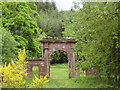
Archway to a castle
This majestic old entrance to Stobs Castle has fell out of favour.
Image: © James Denham
Taken: 2 Jun 2008
0.10 miles
3
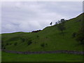
Ancient Lands near Stobs Castle
There was much activity here in pre-mediaeval times, long since gone or covered by the moving sands of time.
Image: © James Denham
Taken: 2 Jun 2008
0.11 miles
4
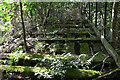
Decaying remains of footbridge, Stobs
Moss-covered and potentially rotten timbers caused a quick change of plan when exiting from the Waverley Line to the fields at Stobs, to avoid crossing this.
Image: © Jim Barton
Taken: 26 Jul 2023
0.23 miles