IMAGES TAKEN NEAR TO
Cornmill, Mill Path, HAWICK, TD9 9EZ
Introduction
This page details the photographs taken nearby to Cornmill, Mill Path, TD9 9EZ by members of the Geograph project.
The Geograph project started in 2005 with the aim of publishing, organising and preserving representative images for every square kilometre of Great Britain, Ireland and the Isle of Man.

There are currently over 7.5m images from over14,400 individuals and you can help contribute to the project by visiting https://www.geograph.org.uk
Image Map
Images are licensed for reuse under creativecommons.org/licenses/by-sa/2.0
Notes
- Clicking on the map will re-center to the selected point.
- The higher the marker number, the further away the image location is from the centre of the postcode.
Image Listing (262 Images Found)
Images are licensed for reuse under creativecommons.org/licenses/by-sa/2.0
Image
Details
Distance
1
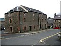
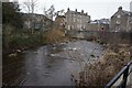
The old Corn Mill in Hawick
The old mill, situated in Mill Path, has been converted to private dwellings.
Image: © James Denham
Taken: 27 May 2014
0.01 miles
2
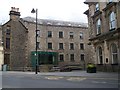
Impressive buildings on Tower Knowe Hawick
The rear of Tower Mill and Border Brides in a former Bank Building.A quote from British Listed Buildings--- 4 Tower Knowe
A fine example of a mid-19th-century, palazzo-style regional bank, built for the Commercial Bank
http://www.britishlistedbuildings.co.uk/sc-34625-4-tower-knowe-
Image: © David Clark
Taken: 16 Apr 2011
0.03 miles
6
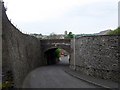
Mill Path heading in towards Hawick town centre
See the tower of St. Mary's Church above the former railway bridge.
Image: © James Denham
Taken: 27 May 2014
0.04 miles
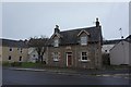
7

Hawick old fire station
Hawick old fire station, Old Manse Lane/Slitrig Bank, Hawick, Lothian & Borders, believed to date from 1857
Image: © Kevin Hale
Taken: 2 Aug 2010
0.05 miles
8
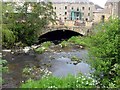
Bridge over the Slitrig Water
At Kirkstile near the Heritage Hub in Hawick.
Image: © James Denham
Taken: 27 May 2014
0.05 miles
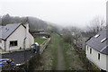
9
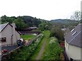
Site of the old Edinburgh to Carlisle railway track
The popular walkway in Hawick was better known as the Waverley Line.
Image: © James Denham
Taken: 27 May 2014
0.05 miles
10
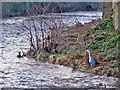
Hopeful Heron at Hawick
The level of the Stilrig Water in Hawick is higher than normal, swollen by the melting of recent heavy snowfall. The heron pictured here is presumably hoping to snatch a morsel from the fast-flowing river.
Image: © Richard Dorrell
Taken: 14 Jan 2011
0.05 miles