IMAGES TAKEN NEAR TO
Towerdykeside, HAWICK, TD9 9EA
Introduction
This page details the photographs taken nearby to Towerdykeside, TD9 9EA by members of the Geograph project.
The Geograph project started in 2005 with the aim of publishing, organising and preserving representative images for every square kilometre of Great Britain, Ireland and the Isle of Man.

There are currently over 7.5m images from over14,400 individuals and you can help contribute to the project by visiting https://www.geograph.org.uk
Image Map
Images are licensed for reuse under creativecommons.org/licenses/by-sa/2.0
Notes
- Clicking on the map will re-center to the selected point.
- The higher the marker number, the further away the image location is from the centre of the postcode.
Image Listing (300 Images Found)
Images are licensed for reuse under creativecommons.org/licenses/by-sa/2.0
Image
Details
Distance
1
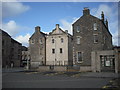
Drumlanrig's Tower Hawick
This old Tower House, for a long time part of a very old hotel called The Tower Hotel, was heavily refurbished in the 1980s to be a museum and information centre.
Image: © Mark Hope
Taken: 9 Mar 2009
0.01 miles
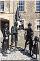
2
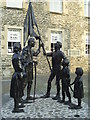
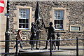
'Return from Hornshole' Monument
This is also known as the 'Quincentenary statue' or the 'Callant's Return'. It was unveiled on 15 May 2014, to celebrate the 500th anniversary of the Hornshole Skirmish. The skirmish, of 1514, a year after the Battle of Flodden, happened when a band of young Hawick men, considered too young to fight with King James IV at Flodden, surprised and routed an English force under Lord Dacre which was camped nearby.
It depicts a callant handing over the captured Hexham Banner to the townspeople of Hawick. The towns people are depicted as either elderly or young because the adult males of the town had mostly died in the battle the year before.
It was sculpted at Beltane Studios, Peebles and cost around £80,000.
Image: © Graham Hale
Taken: 10 Sep 2014
0.01 miles
3
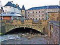
Slitrig Water, Hawick
The river level is high following the melting of heavy winter snowfall. Here it flows under several buildings and roads. The white building on the left is the Hawick Heritage Hub. Contrast with this image by Mark Hope - Image
Image: © Richard Dorrell
Taken: 14 Jan 2011
0.01 miles
6
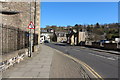
High Street
The western end of the High Street, beyond the Slitrig Water. There has been a lot of regeneration work here.
Image: © Richard Webb
Taken: 21 Jun 2007
0.02 miles
7
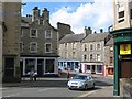
Southern Reporter
Office of the Borders local newspaper.
Image: © Richard Webb
Taken: 21 Jun 2007
0.02 miles
8
New Statue on Hawick High Street
In memory of The Battle of Hornshole.
Image: © Billy McCrorie
Taken: 21 Apr 2015
0.02 miles
9
Statue on the High Street, Hawick
The young save the day at the Battle of Hornshole.
Image: © Billy McCrorie
Taken: 21 Apr 2015
0.02 miles
10
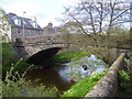
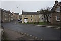
Ancient Bridge at Hawick
This old hump-backed bridge carries traffic on to the Newcastleton Road
Image: © James Denham
Taken: 16 May 2008
0.02 miles