IMAGES TAKEN NEAR TO
Teviot Road, HAWICK, TD9 9DT
Introduction
This page details the photographs taken nearby to Teviot Road, TD9 9DT by members of the Geograph project.
The Geograph project started in 2005 with the aim of publishing, organising and preserving representative images for every square kilometre of Great Britain, Ireland and the Isle of Man.

There are currently over 7.5m images from over14,400 individuals and you can help contribute to the project by visiting https://www.geograph.org.uk
Image Map
Images are licensed for reuse under creativecommons.org/licenses/by-sa/2.0
Notes
- Clicking on the map will re-center to the selected point.
- The higher the marker number, the further away the image location is from the centre of the postcode.
Image Listing (320 Images Found)
Images are licensed for reuse under creativecommons.org/licenses/by-sa/2.0
Image
Details
Distance
1
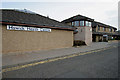
Hawick Health Centre
The health centre, constructed in 1989, is located in Teviot Road on the southeast side of the River Teviot. There are 14 consulting rooms along with dental, physiotherapy, speech therapy, pharmacy and podiatry facilities on the ground floor. Staff facilities and nursing admin offices are on the first floor. At times of severe flooding, there can be problems with the surface water drainage arrangements in this area, and 3 years ago the health centre was flooded. A flood gate system was installed at the external door openings which has been used 2 or 3 times as a precautionary measure to prevent flood water ingress to the building.
Image: © Walter Baxter
Taken: 24 Apr 2010
0.02 miles
2
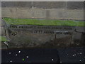
Bench Mark on Hawick Town Hall
This bench mark with height displayed is located on the side street at Hawick Town Hall.
Image: © Colin Park
Taken: 8 Oct 2005
0.04 miles
3
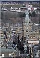
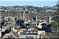
Hawick Town Centre
This telephoto shot with the town hall clock tower prominent centre right was taken from Hawick Motte.
Image: © Walter Baxter
Taken: 1 Apr 2013
0.04 miles
5
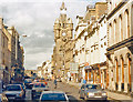
Hawick town centre from the Motte
The Motte on Howegate gives a fine view over the town, with the clock tower of the town hall prominent above the High Street. The Minto Hills are in the distance.
Image: © Jim Barton
Taken: 2 Feb 2013
0.04 miles
7
Hawick: High Street, 1988
View NE -taken from the Carlisle - Galashiels bus - which is all that public transport offered since the Waverley (Railway) Line was closed in 1969.
Image: © Ben Brooksbank
Taken: 19 Aug 1988
0.04 miles
8
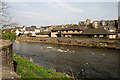
The River Teviot in Hawick
A view from the northwest bank towards the health centre Image] on the southeast side of the river.
Image: © Walter Baxter
Taken: 24 Apr 2010
0.04 miles
9
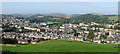
Hawick in the Scottish Borders
This is a view west-southwest from Miller’s Knowes on the southeast side of the town. Hawick sits in the valley of the River Teviot and is the largest town in the Scottish Borders. The town is famous for textiles although this industry has been in decline for several years.
Image: © Walter Baxter
Taken: 21 Sep 2008
0.04 miles
10
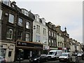
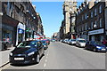
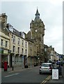
High Street, Hawick, south west side
Image: © Jonathan Thacker
Taken: 3 Nov 2017
0.04 miles