IMAGES TAKEN NEAR TO
HAWICK, TD9 8TS
Introduction
This page details the photographs taken nearby to TD9 8TS by members of the Geograph project.
The Geograph project started in 2005 with the aim of publishing, organising and preserving representative images for every square kilometre of Great Britain, Ireland and the Isle of Man.

There are currently over 7.5m images from over14,400 individuals and you can help contribute to the project by visiting https://www.geograph.org.uk
Image Map
Images are licensed for reuse under creativecommons.org/licenses/by-sa/2.0
Notes
- Clicking on the map will re-center to the selected point.
- The higher the marker number, the further away the image location is from the centre of the postcode.
Image Listing (8 Images Found)
Images are licensed for reuse under creativecommons.org/licenses/by-sa/2.0
Image
Details
Distance
1
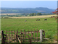
A view over Teviotdale
The house in view is Garthside, a short way east of Denholm.
Image: © Oliver Dixon
Taken: 21 Sep 2014
0.01 miles
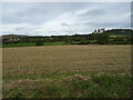
4
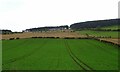
Crop field, Denholm
The land rises up from the River Teviot.
Image: © JThomas
Taken: 11 Oct 2021
0.17 miles
7
Stubble field, Teviotdale
Looking down towards the river.
Image: © JThomas
Taken: 11 Oct 2021
0.24 miles
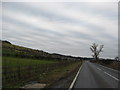
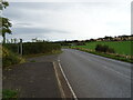
8
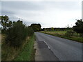
Jedburgh Road (A698), Teviotdale
Towards Jedburgh.
Image: © JThomas
Taken: 11 Oct 2021
0.25 miles