IMAGES TAKEN NEAR TO
HAWICK, TD9 8TL
Introduction
This page details the photographs taken nearby to TD9 8TL by members of the Geograph project.
The Geograph project started in 2005 with the aim of publishing, organising and preserving representative images for every square kilometre of Great Britain, Ireland and the Isle of Man.

There are currently over 7.5m images from over14,400 individuals and you can help contribute to the project by visiting https://www.geograph.org.uk
Image Map
Images are licensed for reuse under creativecommons.org/licenses/by-sa/2.0
Notes
- Clicking on the map will re-center to the selected point.
- The higher the marker number, the further away the image location is from the centre of the postcode.
Image Listing (6 Images Found)
Images are licensed for reuse under creativecommons.org/licenses/by-sa/2.0
Image
Details
Distance
1
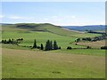
Farmland near Chesters
View of Southdean Law, a hill fort.
Image: © Richard Webb
Taken: 9 Aug 2022
0.18 miles
2
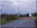
Nearly at Chesters
Heading for the turn to Bonchester Bridge.
Image: © James Denham
Taken: 1 May 2008
0.19 miles
3
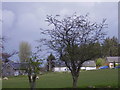
A peaceful scene at Chesters
A view of the village
Image: © James Denham
Taken: 1 May 2008
0.19 miles
4
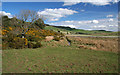
White Burn
White Burn beneath Bents Plantation.
Image: © Peter McDermott
Taken: 11 Apr 2009
0.21 miles
5
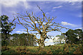
A dead tree near Whiteburn
A Dutch elm disease victim by the A6088 road south of Chesters.
Image: © Walter Baxter
Taken: 2 Jul 2010
0.24 miles
6
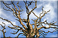
A dead elm tree near Whiteburn
A closer view of the upper part of this tree Image
Image: © Walter Baxter
Taken: 2 Jul 2010
0.24 miles