IMAGES TAKEN NEAR TO
Minto, HAWICK, TD9 8SD
Introduction
This page details the photographs taken nearby to TD9 8SD by members of the Geograph project.
The Geograph project started in 2005 with the aim of publishing, organising and preserving representative images for every square kilometre of Great Britain, Ireland and the Isle of Man.

There are currently over 7.5m images from over14,400 individuals and you can help contribute to the project by visiting https://www.geograph.org.uk
Image Map
Images are licensed for reuse under creativecommons.org/licenses/by-sa/2.0
Notes
- Clicking on the map will re-center to the selected point.
- The higher the marker number, the further away the image location is from the centre of the postcode.
Image Listing (5 Images Found)
Images are licensed for reuse under creativecommons.org/licenses/by-sa/2.0
Image
Details
Distance
1
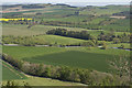
A superb view
Standing next to the Peel Tower on Minto Hill gives you a wonderful view to the NE.
Image: © Malcolm Neal
Taken: 3 May 2017
0.14 miles
2

Autumn colours above Minto
The road winds its way through the belt of woodland improbably known as the New Pink Strip.
Image: © Oliver Dixon
Taken: 24 Oct 2014
0.16 miles
3

Looking over the Pink Strips
With Minto Mames in the background.
Image: © James Denham
Taken: 28 Feb 2014
0.18 miles
4
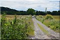
Estate track, Minto
Part of a network of tracks and roads in the estate around Minto House.
Image: © Jim Barton
Taken: 19 Jul 2012
0.20 miles
5

Ash avenue, Hillend
Road descending to Minto overhung with ash trees.
Image: © Richard Webb
Taken: 5 Oct 2007
0.22 miles