IMAGES TAKEN NEAR TO
HAWICK, TD9 8QT
Introduction
This page details the photographs taken nearby to TD9 8QT by members of the Geograph project.
The Geograph project started in 2005 with the aim of publishing, organising and preserving representative images for every square kilometre of Great Britain, Ireland and the Isle of Man.

There are currently over 7.5m images from over14,400 individuals and you can help contribute to the project by visiting https://www.geograph.org.uk
Image Map
Images are licensed for reuse under creativecommons.org/licenses/by-sa/2.0
Notes
- Clicking on the map will re-center to the selected point.
- The higher the marker number, the further away the image location is from the centre of the postcode.
Image Listing (11 Images Found)
Images are licensed for reuse under creativecommons.org/licenses/by-sa/2.0
Image
Details
Distance
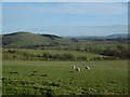
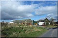
4
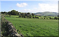
Hawthornside Farm in rolling Border countryside
Image: © Walter Baxter
Taken: 30 Sep 2006
0.04 miles
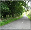
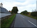
7
Minor road approaching the A6088 road at Peel Knowe
Looking south-westward.
Image: © Peter Wood
Taken: 14 Dec 2018
0.11 miles
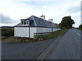
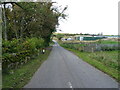
9
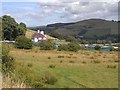
Phantasy Kennels
Kennels beside the A6088 on the descent into Bonchester Bridge. Bonchester Hill Image can be seen on the far side of the valley.
Image: © Oliver Dixon
Taken: 2 Aug 2009
0.22 miles