IMAGES TAKEN NEAR TO
HAWICK, TD9 8QP
Introduction
This page details the photographs taken nearby to TD9 8QP by members of the Geograph project.
The Geograph project started in 2005 with the aim of publishing, organising and preserving representative images for every square kilometre of Great Britain, Ireland and the Isle of Man.

There are currently over 7.5m images from over14,400 individuals and you can help contribute to the project by visiting https://www.geograph.org.uk
Image Map
Images are licensed for reuse under creativecommons.org/licenses/by-sa/2.0
Notes
- Clicking on the map will re-center to the selected point.
- The higher the marker number, the further away the image location is from the centre of the postcode.
Image Listing (8 Images Found)
Images are licensed for reuse under creativecommons.org/licenses/by-sa/2.0
Image
Details
Distance
2
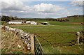
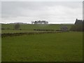
Farmland at Whitriggs
Viewed from the edge of the square by a minor road to Denholm with buildings in the background at Whitriggs Farm.
Image: © Walter Baxter
Taken: 3 Apr 2011
0.08 miles
3
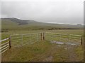
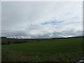
Two gates, Effledge
Entrance to a couple of fields under Rubers Law.
Image: © Richard Webb
Taken: 4 Mar 2016
0.08 miles
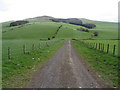
4
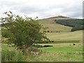
Under Rubers Law
Grown out hedgerows at Whitrigs with Rubers Law in the background.
Image: © Richard Webb
Taken: 20 Aug 2007
0.11 miles
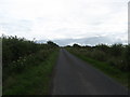
8
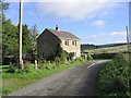
Farm road
A road opposite Whitriggs Farm with Rubers Law in the background.
Image: © Walter Baxter
Taken: 8 May 2007
0.25 miles