IMAGES TAKEN NEAR TO
Croft Field, Jedward Terrace, HAWICK, TD9 8QB
Introduction
This page details the photographs taken nearby to Croft Field, Jedward Terrace, TD9 8QB by members of the Geograph project.
The Geograph project started in 2005 with the aim of publishing, organising and preserving representative images for every square kilometre of Great Britain, Ireland and the Isle of Man.

There are currently over 7.5m images from over14,400 individuals and you can help contribute to the project by visiting https://www.geograph.org.uk
Image Map
Images are licensed for reuse under creativecommons.org/licenses/by-sa/2.0
Notes
- Clicking on the map will re-center to the selected point.
- The higher the marker number, the further away the image location is from the centre of the postcode.
Image Listing (89 Images Found)
Images are licensed for reuse under creativecommons.org/licenses/by-sa/2.0
Image
Details
Distance
1
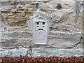
Ordnance Survey Flush Bracket 1498
This can be found on the wall of the former Police Station - now a private dwelling - in Denholm.
For more detail see : http://www.bench-marks.org.uk/log?bm_key=1593
Image: © Peter Wood
Taken: 11 Oct 2015
0.05 miles
2
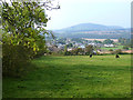
A prospect of Denholm
The easstern end of the village of Denholm seen from the Loaning. The hills in the distance are the Minto Hills Image
Image: © Oliver Dixon
Taken: 21 Sep 2014
0.05 miles
3
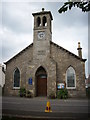
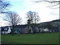
Parish Kirk of Ruberslaw
The former United Free Kirk at Denholm is now Church of Scotland and serves the Parish of Ruberslaw. The humble wee church is situated on the eastern side of the village green in Denholm on the Jedburgh to Hawick road in the Scottish Borders
Image: © James Denham
Taken: 30 Aug 2008
0.08 miles
4
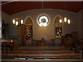
The interior of Denholm Church in Roxburghshire.
Built in the 19th. century as a Free Church, Denholm became part of the Church of Scotland in 1929.
Image: © James Denham
Taken: 2 Feb 2011
0.09 miles
7

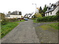
Cannongate, Denholm
A residential side road NE from the village green. The wooded hill in the background is Minto Craigs. The green sign indicates the Borders Abbeys Way route to Hawick.
Image: © Jim Barton
Taken: 12 Jul 2012
0.09 miles
8
A part of Cannongate in Denholm
Looking south-westward.
Image: © Peter Wood
Taken: 14 Oct 2018
0.10 miles
9
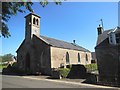
Ruberslaw Parish Church of Scotland , Denholm
Image: © Bill Henderson
Taken: 22 Jul 2014
0.10 miles
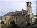
10
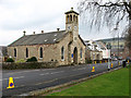
Ruberslaw Parish Church
This church (1844) is on the northeast side of the village green. The southwest facing clock face is dated 1885 and a stone tablet above the entrance door is inscribed:-
FREE CHURCH
MDCCCXLIV
Image: © Walter Baxter
Taken: 12 Apr 2008
0.11 miles