IMAGES TAKEN NEAR TO
HAWICK, TD9 8PP
Introduction
This page details the photographs taken nearby to TD9 8PP by members of the Geograph project.
The Geograph project started in 2005 with the aim of publishing, organising and preserving representative images for every square kilometre of Great Britain, Ireland and the Isle of Man.

There are currently over 7.5m images from over14,400 individuals and you can help contribute to the project by visiting https://www.geograph.org.uk
Image Map
Images are licensed for reuse under creativecommons.org/licenses/by-sa/2.0
Notes
- Clicking on the map will re-center to the selected point.
- The higher the marker number, the further away the image location is from the centre of the postcode.
Image Listing (8 Images Found)
Images are licensed for reuse under creativecommons.org/licenses/by-sa/2.0
Image
Details
Distance
1
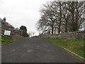
Steep entrance to Newton Farm north of Hawick
In the Scottish Borders.
Image: © James Denham
Taken: 18 Apr 2010
0.01 miles
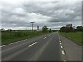
2

A7, Newton
Anticyclonic Autumn weather: fog fills Teviotdale.
Image: © Richard Webb
Taken: 3 Nov 2015
0.02 miles
4

A7, Newton
About to descend into foggy Teviotdale in anticyclonic conditions.
Image: © Richard Webb
Taken: 3 Nov 2015
0.08 miles
5
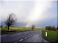
Rainbow over the A7
Looking across the Boonraw Burn
Image: © Dumgoyach
Taken: 23 Nov 2006
0.13 miles
6
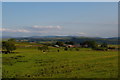
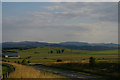
View south from the A7 layby north of Newton
The farm in the middle distance is at Newton, in Image
Image: © Christopher Hilton
Taken: 18 Aug 2016
0.20 miles
7
The A7 north of Hawick
The farm in the middle distance is at Newton, in Image
Image: © Christopher Hilton
Taken: 18 Aug 2016
0.23 miles
8
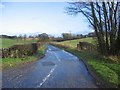
Road leading to Appletreehall
Just north of Hawick
Image: © Dumgoyach
Taken: 23 Nov 2006
0.23 miles