IMAGES TAKEN NEAR TO
HAWICK, TD9 8PH
Introduction
This page details the photographs taken nearby to TD9 8PH by members of the Geograph project.
The Geograph project started in 2005 with the aim of publishing, organising and preserving representative images for every square kilometre of Great Britain, Ireland and the Isle of Man.

There are currently over 7.5m images from over14,400 individuals and you can help contribute to the project by visiting https://www.geograph.org.uk
Image Map
Images are licensed for reuse under creativecommons.org/licenses/by-sa/2.0
Notes
- Clicking on the map will re-center to the selected point.
- The higher the marker number, the further away the image location is from the centre of the postcode.
Image Listing (15 Images Found)
Images are licensed for reuse under creativecommons.org/licenses/by-sa/2.0
Image
Details
Distance
3

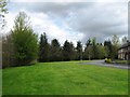
Ancrum Court
Residential area on the northern edge of Hawick.
Image: © Richard Webb
Taken: 3 Nov 2015
0.13 miles
6
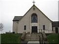
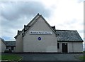
Burnfoot Parish Church, Hawick
The west, entrance facade.
Image: © James Denham
Taken: 15 Mar 2012
0.17 miles
8
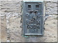
Ordnance Survey Flush Bracket G374
This can be found on the roadside wall of the Cemetery Lodge at Hawick.
For more detail see : http://www.bench-marks.org.uk/bm11123
Image: © Peter Wood
Taken: 11 Oct 2015
0.22 miles
9
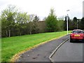
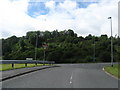
The view from the steps at Burnfoot Church
Looking down Fraser Avenue with the .hazy hills in the background
Image: © James Denham
Taken: 15 Mar 2012
0.22 miles
10
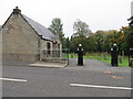
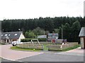
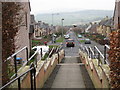
Cemetery Lodge and entrance at Wilton Hill in Hawick
Looking south-eastward.
Image: © Peter Wood
Taken: 11 Oct 2015
0.22 miles