IMAGES TAKEN NEAR TO
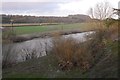
Teviotbank Gardens, HAWICK, TD9 8PB
Introduction
This page details the photographs taken nearby to Teviotbank Gardens, TD9 8PB by members of the Geograph project.
The Geograph project started in 2005 with the aim of publishing, organising and preserving representative images for every square kilometre of Great Britain, Ireland and the Isle of Man.

There are currently over 7.5m images from over14,400 individuals and you can help contribute to the project by visiting https://www.geograph.org.uk
Image Map
Images are licensed for reuse under creativecommons.org/licenses/by-sa/2.0
Notes
- Clicking on the map will re-center to the selected point.
- The higher the marker number, the further away the image location is from the centre of the postcode.
Image Listing (57 Images Found)
Images are licensed for reuse under creativecommons.org/licenses/by-sa/2.0
Image
Details
Distance
1
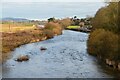
The River Teviot at Denholm
Looking downstream from the road bridge.
Image: © Jim Barton
Taken: 26 Nov 2020
0.04 miles
2
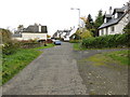
A part of Cannongate in Denholm
Looking south-westward.
Image: © Peter Wood
Taken: 14 Oct 2018
0.07 miles
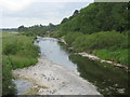
3
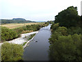
River Teviot
Looking downstream from Denholm Bridge.
Image: © Oliver Dixon
Taken: 22 Sep 2014
0.08 miles
4
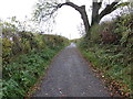
Minor road from Denholm to the A698 road
Looking south-eastward.
Image: © Peter Wood
Taken: 14 Oct 2018
0.09 miles
5
River Teviot, Denholm
Evidence of recent flooding.
Image: © Richard Webb
Taken: 2 Feb 2016
0.09 miles
6

Cannongate, Denholm
A residential side road NE from the village green. The wooded hill in the background is Minto Craigs. The green sign indicates the Borders Abbeys Way route to Hawick.
Image: © Jim Barton
Taken: 12 Jul 2012
0.09 miles
7
The River Teviot
Here the river is flowing downstream at Denholm towards its confluence with the River Tweed near Roxburgh.
Image: © James Denham
Taken: 25 Jun 2010
0.10 miles
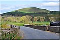
8

Bridge over the River Teviot, Denholm
The bridge carries the B6405 northwards from the village. There is a small car park out of shot on the right before the bridge. In the background is the higher of the two Minto Hills.
Image: © Jim Barton
Taken: 12 Jul 2012
0.11 miles
9
Teviot Bridge, Denholm
The bridge for the B6405 to Hassendean with the southernmost Minto hill (276m) beyond.
Image: © Jim Barton
Taken: 22 Apr 2017
0.11 miles
10
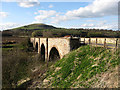
Denholm Bridge
On Minto Road over the River Teviot and dated 1864. The Minto Hills are in the background.
Image: © Walter Baxter
Taken: 14 Apr 2008
0.11 miles