IMAGES TAKEN NEAR TO
Westside, HAWICK, TD9 8LX
Introduction
This page details the photographs taken nearby to Westside, TD9 8LX by members of the Geograph project.
The Geograph project started in 2005 with the aim of publishing, organising and preserving representative images for every square kilometre of Great Britain, Ireland and the Isle of Man.

There are currently over 7.5m images from over14,400 individuals and you can help contribute to the project by visiting https://www.geograph.org.uk
Image Map
Images are licensed for reuse under creativecommons.org/licenses/by-sa/2.0
Notes
- Clicking on the map will re-center to the selected point.
- The higher the marker number, the further away the image location is from the centre of the postcode.
Image Listing (92 Images Found)
Images are licensed for reuse under creativecommons.org/licenses/by-sa/2.0
Image
Details
Distance
1
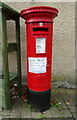
Postbox on Westside, Denholm
In front of the Post Office.
Postbox No. TD9 70.
See Image] for context.
Image: © JThomas
Taken: 11 Oct 2021
0.01 miles
2
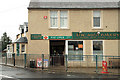
Denholm Post Office
At the southwest end of the village and still open for now. Many of the small rural post offices are under threat of closure.
Image: © Walter Baxter
Taken: 12 Apr 2008
0.01 miles
3
Denholm Post Office
Showing position of Postbox No. TD9 70.
See Image] for postbox.
Image: © JThomas
Taken: 11 Oct 2021
0.02 miles
4
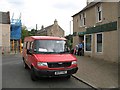
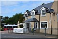
Post Office, Denholm
Post bus outside the post office and bakery, Denholm. Now that the GPO has gone corporate, these services are disappearing - as are the post offices themselves.
Image: © Richard Webb
Taken: 20 Aug 2007
0.02 miles
5
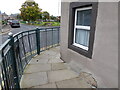
Corner of Westgate and Main Street
A benchmark symbol is visible near the corner of the house wall (photograph Image).
Image: © Adrian Taylor
Taken: 28 Sep 2020
0.02 miles
6
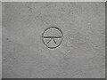
Benchmark symbol
Detail of a benchmark type symbol on a house wall at the corner of Westgate and Main Street. The Ordnance Survey database indicates a cut benchmark at this location, marking a height of 88.459m above sea level (Ordnance Datum Newlyn) last verified in 1954. This mark does not appear to be the original benchmark but may indicate the approximate position of the original under the cement harling (location photograph Image).
Image: © Adrian Taylor
Taken: 28 Sep 2020
0.02 miles
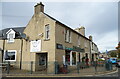
7
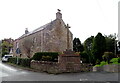
The Denholm Meet
A café and restaurant with an upstairs antiques gallery next door to the Post Office. Note the shelter for additional outdoor seating by the car park.
Image: © Jim Barton
Taken: 9 Aug 2020
0.02 miles
9
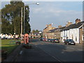
Main Street, Denholm
The village of Denholm is about 6 miles northeast of Hawick.
The gates and railings which used to run along the side of the Denholm Green (to the left of picture) were requisitioned in WWII.
In the 19th century circus animals passing through the village used to take water from a trough beside where the phone box (which is marked on the larger-scale map) now stands.
Image: © Barbara Carr
Taken: 3 Sep 2010
0.03 miles
10
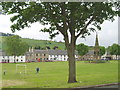
The Green, Denholm
Denholm, a planned village laid out in the 17th century, is nowadays a Conservation Area. The monument on the Green commemorates Dr John Leyden, a poet and linguist who was born in the village in 1775.
Image: © Eileen Henderson
Taken: 27 May 2006
0.03 miles