IMAGES TAKEN NEAR TO
HAWICK, TD9 8HZ
Introduction
This page details the photographs taken nearby to TD9 8HZ by members of the Geograph project.
The Geograph project started in 2005 with the aim of publishing, organising and preserving representative images for every square kilometre of Great Britain, Ireland and the Isle of Man.

There are currently over 7.5m images from over14,400 individuals and you can help contribute to the project by visiting https://www.geograph.org.uk
Image Map
Images are licensed for reuse under creativecommons.org/licenses/by-sa/2.0
Notes
- Clicking on the map will re-center to the selected point.
- The higher the marker number, the further away the image location is from the centre of the postcode.
Image Listing (12 Images Found)
Images are licensed for reuse under creativecommons.org/licenses/by-sa/2.0
Image
Details
Distance
1
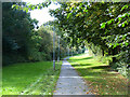
Waverley Walk, Hawick
This footpath runs into Hawick along the line of the old "Waverley" line from Carlisle to Edinburgh. Here it is followed by the Border Abbeys Way, a circular long-distance walking route in the Scottish Borders.
Image: © Oliver Dixon
Taken: 22 Sep 2014
0.14 miles
2
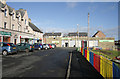
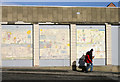
Shops at Burnfoot, Hawick
The small shops on the left and a Co-operative store ahead are located at Kenilworth Avenue in the Burnfoot housing scheme.
Image: © Walter Baxter
Taken: 9 Mar 2011
0.14 miles
3
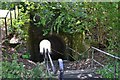
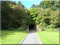
Pedestrian underpass, former Waverley Line
A pedestrian tunnel under the embankment of the dismantled railway line, east of the Teviotdale Leisure Centre built on the site of the former station.
Image: © Jim Barton
Taken: 2 Aug 2013
0.15 miles
4
Walking by the Co-op Store at Burnfoot, Hawick
This is a section of the south elevation of the store at Kenilworth Avenue where children’s murals have been fixed to the external wall panels. For a view of the store beside some small shops, see Image
Image: © Walter Baxter
Taken: 9 Mar 2011
0.15 miles
5
Pedestrian tunnel under the old Waverley line
This tunnel carries a path steeply upwards under the old "Waverley" line from Carlisle to Edinburgh.
Image: © Oliver Dixon
Taken: 22 Sep 2014
0.17 miles
6
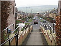
The view from the steps at Burnfoot Church
Looking down Fraser Avenue with the .hazy hills in the background
Image: © James Denham
Taken: 15 Mar 2012
0.19 miles
7
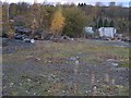
Industrial site off Mansfield Road
Looks like the site of a demolished factory or gas works. Some of the land is a depot for Scottish Borders Council, other parts are being colonised by birch.
Camera poked through chain link fencing.
Image: © Richard Webb
Taken: 2 Nov 2007
0.19 miles
8
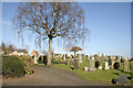
Wilton Cemetery in Hawick
This cemetery is on the north side of the town below Burnfoot housing scheme. For a view of the cemetery from Miller’s Knowes, see Image
Image: © Walter Baxter
Taken: 6 Mar 2011
0.21 miles
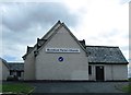
9
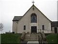
Burnfoot Parish Church, Hawick
The west, entrance facade.
Image: © James Denham
Taken: 15 Mar 2012
0.23 miles