IMAGES TAKEN NEAR TO
McLagan Drive, HAWICK, TD9 8BT
Introduction
This page details the photographs taken nearby to McLagan Drive, TD9 8BT by members of the Geograph project.
The Geograph project started in 2005 with the aim of publishing, organising and preserving representative images for every square kilometre of Great Britain, Ireland and the Isle of Man.

There are currently over 7.5m images from over14,400 individuals and you can help contribute to the project by visiting https://www.geograph.org.uk
Image Map
Images are licensed for reuse under creativecommons.org/licenses/by-sa/2.0
Notes
- Clicking on the map will re-center to the selected point.
- The higher the marker number, the further away the image location is from the centre of the postcode.
Image Listing (13 Images Found)
Images are licensed for reuse under creativecommons.org/licenses/by-sa/2.0
Image
Details
Distance
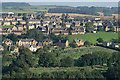
1
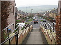
The view from the steps at Burnfoot Church
Looking down Fraser Avenue with the .hazy hills in the background
Image: © James Denham
Taken: 15 Mar 2012
0.13 miles
3
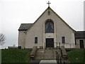
Burnfoot Parish Church, Hawick
The west, entrance facade.
Image: © James Denham
Taken: 15 Mar 2012
0.15 miles
6
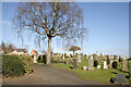
Wilton Cemetery in Hawick
This cemetery is on the north side of the town below Burnfoot housing scheme. For a view of the cemetery from Miller’s Knowes, see Image
Image: © Walter Baxter
Taken: 6 Mar 2011
0.18 miles
7
Wilton cemetery in Hawick
Set within a housing scheme at Burnfoot and viewed from Miller's Knowes.
Image: © Walter Baxter
Taken: 21 Sep 2008
0.20 miles
8
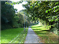
Waverley Walk, Hawick
This footpath runs into Hawick along the line of the old "Waverley" line from Carlisle to Edinburgh. Here it is followed by the Border Abbeys Way, a circular long-distance walking route in the Scottish Borders.
Image: © Oliver Dixon
Taken: 22 Sep 2014
0.22 miles
9
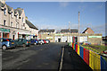
Shops at Burnfoot, Hawick
The small shops on the left and a Co-operative store ahead are located at Kenilworth Avenue in the Burnfoot housing scheme.
Image: © Walter Baxter
Taken: 9 Mar 2011
0.22 miles
10
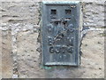
Ordnance Survey Flush Bracket G374
This can be found on the roadside wall of the Cemetery Lodge at Hawick.
For more detail see : http://www.bench-marks.org.uk/bm11123
Image: © Peter Wood
Taken: 11 Oct 2015
0.22 miles