IMAGES TAKEN NEAR TO
West Stewart Place, HAWICK, TD9 8BH
Introduction
This page details the photographs taken nearby to West Stewart Place, TD9 8BH by members of the Geograph project.
The Geograph project started in 2005 with the aim of publishing, organising and preserving representative images for every square kilometre of Great Britain, Ireland and the Isle of Man.

There are currently over 7.5m images from over14,400 individuals and you can help contribute to the project by visiting https://www.geograph.org.uk
Image Map
Images are licensed for reuse under creativecommons.org/licenses/by-sa/2.0
Notes
- Clicking on the map will re-center to the selected point.
- The higher the marker number, the further away the image location is from the centre of the postcode.
Image Listing (60 Images Found)
Images are licensed for reuse under creativecommons.org/licenses/by-sa/2.0
Image
Details
Distance
1
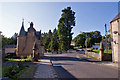
23 Havelock Street, Hawick
The house on the left is number 23, a former gate lodge, probably designed by John Thomas Rochead, and built in the later 19th century. It is Grade B listed.
Image: © Richard Dorrell
Taken: 6 Sep 2015
0.06 miles
2
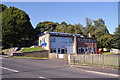
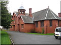
Hawick Youth Centre
Located in Havelock Street.
Image: © Richard Dorrell
Taken: 6 Sep 2015
0.08 miles
3
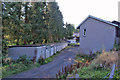
Disused garages
From their appearance, it would seem that few if any of these garages are still in regular use. They are located at the rear of housing in Havelock Street, Hawick.
Image: © Richard Dorrell
Taken: 6 Sep 2015
0.10 miles
4
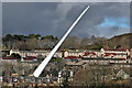
A wind turbine blade moving through Hawick
This 65 metre blade weighing 16 tonnes was photographed from an elevated position at the roundabout near Morrisons as it was slowly moving on the A7 at Wilton Hill. The blades are transported on a blade lifter from a transition point near St Boswells to the Pines Burn Wind Farm approximately 6km southwest of Bonchester Bridge. On straight roads the blade is almost horizontal but on tight corners and in built up areas the blade can be raised to an angle of sixty degrees.
Image: © Walter Baxter
Taken: 24 Feb 2024
0.12 miles
5
The Wilton Church Hall
At the rear of the Parish Kirk.
Image: © James Denham
Taken: 15 Mar 2012
0.13 miles
6
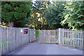
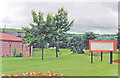
Pedestrian entrance to Wilton Primary School
Located in Wellfield Road, this suburban school has a very rural-looking pedestrian entrance.
School building: Image]
Image: © Richard Dorrell
Taken: 6 Sep 2015
0.13 miles
7
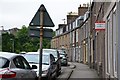
Princes Street, Hawick
The Borders Abbeys Way long-distance path leaves Hawick by this street on the route to Selkirk.
Image: © Jim Barton
Taken: 24 Jul 2014
0.14 miles
8
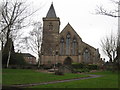
Wilton Parish Church
The magnificent building stands high above the left bank of the River Teviot at Hawick.
Image: © James Denham
Taken: 15 Mar 2012
0.15 miles
9
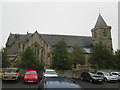
Wilton Parish Church. Hawick
Built 1860-2
Image: © Martin Dawes
Taken: 9 Sep 2019
0.15 miles
10
Site of Hawick station, now Teviot Leisure Centre, 1998
View SW, towards Carlisle: ex-NBR Edinburgh - Hawick - Carlisle main line (Waverley Route), closed 6/1/69 (passengers), 28/4/69 (goods). (Cf. Image]).
Image: © Ben Brooksbank
Taken: 29 Jun 1998
0.15 miles