IMAGES TAKEN NEAR TO
HAWICK, TD9 7NU
Introduction
This page details the photographs taken nearby to TD9 7NU by members of the Geograph project.
The Geograph project started in 2005 with the aim of publishing, organising and preserving representative images for every square kilometre of Great Britain, Ireland and the Isle of Man.

There are currently over 7.5m images from over14,400 individuals and you can help contribute to the project by visiting https://www.geograph.org.uk
Image Map
Images are licensed for reuse under creativecommons.org/licenses/by-sa/2.0
Notes
- Clicking on the map will re-center to the selected point.
- The higher the marker number, the further away the image location is from the centre of the postcode.
Image Listing (6 Images Found)
Images are licensed for reuse under creativecommons.org/licenses/by-sa/2.0
Image
Details
Distance
2
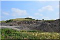
Quarry near Calaburn
A small quarry near the access road to Calaburn.
Image: © Jim Barton
Taken: 13 Aug 2015
0.16 miles
3
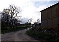
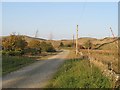
Entrance to Calaburn Farm
North of Mervin's Law near Hawick in Roxburghshire.
Image: © James Denham
Taken: 11 May 2014
0.17 miles
4
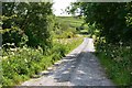
Drove Road near Calaburn
The Cross Borders Drove Road on its gentle ascent of Whitehaugh Moor.
Image: © Jim Barton
Taken: 13 Aug 2015
0.20 miles
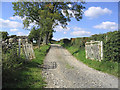
5
Drove Road
One of the main routes for cattle being driven to England descends towards Hawick. Now a farm track and the driveway to Whitehaughmoor.
Image: © Richard Webb
Taken: 23 Oct 2007
0.20 miles
6
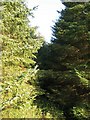
The Cala Burn
The unseen Cala Burn forces a way through a small spruce plantation.
Image: © Richard Webb
Taken: 23 Oct 2007
0.21 miles