IMAGES TAKEN NEAR TO
Borthwickbrae, HAWICK, TD9 7LZ
Introduction
This page details the photographs taken nearby to Borthwickbrae, TD9 7LZ by members of the Geograph project.
The Geograph project started in 2005 with the aim of publishing, organising and preserving representative images for every square kilometre of Great Britain, Ireland and the Isle of Man.

There are currently over 7.5m images from over14,400 individuals and you can help contribute to the project by visiting https://www.geograph.org.uk
Image Map
Images are licensed for reuse under creativecommons.org/licenses/by-sa/2.0
Notes
- Clicking on the map will re-center to the selected point.
- The higher the marker number, the further away the image location is from the centre of the postcode.
Image Listing (15 Images Found)
Images are licensed for reuse under creativecommons.org/licenses/by-sa/2.0
Image
Details
Distance
2
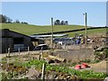
Burnfoot
Stock sheds at Burnfoot.View north.
Image: © Richard Webb
Taken: 12 Jan 2006
0.13 miles
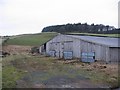
3
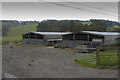
A pair of large barns
These barns look enormous.
Image: © Malcolm Neal
Taken: 30 Apr 2017
0.13 miles
4
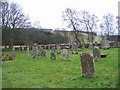
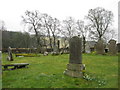
Cemetery
Old cemetery by the Borthwick water, I don't know the name.
Image: © Richard Webb
Taken: 12 Jan 2006
0.17 miles
5
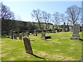
Borthwick Water Cemetery
At Borthwickbrae in Roxburghshire.
Image: © James Denham
Taken: 15 Mar 2011
0.19 miles
6
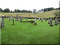
Borthwick Water Cemetery
As is often the case in Scotland, the cemetery is far removed from the settlements which it serves.
Image: © Oliver Dixon
Taken: 23 Apr 2015
0.19 miles
7
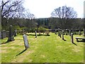
Part of Borthwick Cemetery near Burnfoot
Looking north-westward.
Image: © Peter Wood
Taken: 28 Sep 2021
0.20 miles
8
Borthwick Water Cemetery
As is often the case in Scotland, the cemetery is far removed from the settlements which it serves.
Image: © Oliver Dixon
Taken: 23 Apr 2015
0.20 miles
9
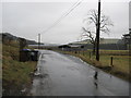
Road heading back to Burnfoot Farm
Near Woodburn in Roxburghshire.
Image: © James Denham
Taken: 15 Mar 2011
0.20 miles
10
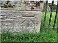
Ordnance Survey Cut Mark
This mark can be found a gatepost at the entrance to Borthwick Cemetery, Burnfoot.
The recorded details give a height of 170.29 metres above sea level.
For more details see : https://www.bench-marks.org.uk/bm164980
Image: © Peter Wood
Taken: 28 Sep 2021
0.21 miles