IMAGES TAKEN NEAR TO
HAWICK, TD9 7LX
Introduction
This page details the photographs taken nearby to TD9 7LX by members of the Geograph project.
The Geograph project started in 2005 with the aim of publishing, organising and preserving representative images for every square kilometre of Great Britain, Ireland and the Isle of Man.

There are currently over 7.5m images from over14,400 individuals and you can help contribute to the project by visiting https://www.geograph.org.uk
Image Map
Images are licensed for reuse under creativecommons.org/licenses/by-sa/2.0
Notes
- Clicking on the map will re-center to the selected point.
- The higher the marker number, the further away the image location is from the centre of the postcode.
Image Listing (21 Images Found)
Images are licensed for reuse under creativecommons.org/licenses/by-sa/2.0
Image
Details
Distance
1
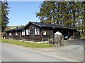
Large wooden hut at Roberton
The gateway leads to the right into the car park of the Forman Memorial Hall, opened in 1923 by John Buchan. The hut appears to be in use as a store.
Image: © Oliver Dixon
Taken: 23 Apr 2015
0.05 miles
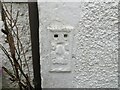
3
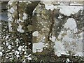
Ordnance Survey Cut Mark
This mark can be found on the wall of Roberton Kirk.
The recorded details give a height of 175.298 metres above sea level.
For more details see : https://www.bench-marks.org.uk/bm164981
Image: © Peter Wood
Taken: 28 Sep 2021
0.08 miles
4
Road (B711) at Roberton Kirk
Looking south-eastward.
Image: © Peter Wood
Taken: 28 Sep 2021
0.09 miles
5
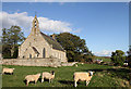
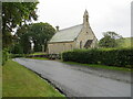
Roberton Kirk
The present church was opened in 1864 and replaced a church about 500m north on the hillside above the hamlet. The church forms a shared parish along with Teviot Church in Hawick. ‘The flock’ outside the church boundary wall awaits the next service.
Image: © Walter Baxter
Taken: 7 Oct 2011
0.09 miles
6
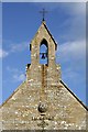
The bellcote at Roberton Kirk
The bellcote is on the west gable wall where there is a relief carving of the Burning Bush. For a wider view of the church, see Image
Image: © Walter Baxter
Taken: 7 Oct 2011
0.09 miles
7
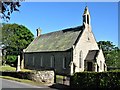
Roberton Kirk
Roberton Kirk is a simple church in an attractive setting in the small village of Roberton. Services take place at various time intervals but approximately every 4 weeks.
Image: © G Laird
Taken: 23 May 2018
0.09 miles
8
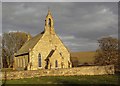
Roberton Kirk
Roberton Kirk in the small hamlet of Roberton.
Image: © Colin Kinnear
Taken: 22 Apr 2010
0.10 miles
9
Ordnance Survey Flush Bracket G489
This bracket can be found on the wall of The Old School House - a private dwelling - at Roberton.
The recorded details give a height of 187.95 metres above sea level.
For more details see : https://www.bench-marks.org.uk/bm11300
Image: © Peter Wood
Taken: 28 Sep 2021
0.10 miles
10
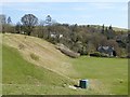
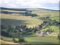
A view of Roberton
A hamlet in the valley of the Borthwick Water
Image: © Oliver Dixon
Taken: 23 Apr 2015
0.11 miles