IMAGES TAKEN NEAR TO
HAWICK, TD9 7LR
Introduction
This page details the photographs taken nearby to TD9 7LR by members of the Geograph project.
The Geograph project started in 2005 with the aim of publishing, organising and preserving representative images for every square kilometre of Great Britain, Ireland and the Isle of Man.

There are currently over 7.5m images from over14,400 individuals and you can help contribute to the project by visiting https://www.geograph.org.uk
Image Map
Images are licensed for reuse under creativecommons.org/licenses/by-sa/2.0
Notes
- Clicking on the map will re-center to the selected point.
- The higher the marker number, the further away the image location is from the centre of the postcode.
Image Listing (8 Images Found)
Images are licensed for reuse under creativecommons.org/licenses/by-sa/2.0
Image
Details
Distance
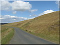
1
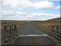
This way to Ashkirk
The road crosses a cattle grid on its way past Esdale Law in the Scottish Borders.
Image: © James Denham
Taken: 20 Apr 2010
0.03 miles
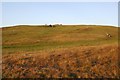
2
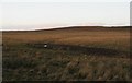
Blawearie
Looking over rough hill grazing towards Esdale Law in Selkirkshire.
Image: © Richard Webb
Taken: 11 Nov 2006
0.05 miles
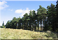
3
Rough grasslands near Blawearie
In the Scottish Borders.
Image: © James Denham
Taken: 20 Apr 2010
0.07 miles
4
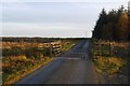
This way to Roberton
A cattle grid on the hill road at Blawearie.
Image: © Richard Webb
Taken: 3 Nov 2015
0.07 miles
6
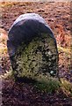
Old Milestone by Blawearie, Ashkirk parish
Milestone by the UC road, in parish of Ashkirk (Selkirk District), Blawearie, on unfenced verge near wood, West side of road.
Inscription once read:-
(Selkirk / 10) :
Surveyed
Milestone Society National ID: BD_SKBT10
Image: © Milestone Society
Taken: Unknown
0.11 miles
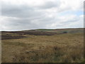
7
Esdale Law
Hill grazing beside the Ashkirk-Roberton hill road.
Image: © Richard Webb
Taken: 3 Nov 2015
0.17 miles
8
The hill road to Ashkirk
On its way past Esdale Law.
Image: © James Denham
Taken: 20 Apr 2010
0.23 miles