IMAGES TAKEN NEAR TO
HAWICK, TD9 7LL
Introduction
This page details the photographs taken nearby to TD9 7LL by members of the Geograph project.
The Geograph project started in 2005 with the aim of publishing, organising and preserving representative images for every square kilometre of Great Britain, Ireland and the Isle of Man.

There are currently over 7.5m images from over14,400 individuals and you can help contribute to the project by visiting https://www.geograph.org.uk
Image Map
Images are licensed for reuse under creativecommons.org/licenses/by-sa/2.0
Notes
- Clicking on the map will re-center to the selected point.
- The higher the marker number, the further away the image location is from the centre of the postcode.
Image Listing (6 Images Found)
Images are licensed for reuse under creativecommons.org/licenses/by-sa/2.0
Image
Details
Distance
1

Hawick from the air
This view shows the striations in the hills to the west of the town.
Image: © Thomas Nugent
Taken: 9 Feb 2018
0.04 miles
2
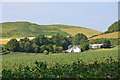
Wiltonburn farm
Seen from the path near Brieryhill.
Image: © Jim Barton
Taken: 13 Aug 2015
0.04 miles
3
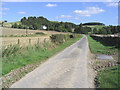
Looking down the unclassified road from Wiltonburn
Image: © Walter Baxter
Taken: 8 Sep 2006
0.11 miles
4
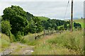
Path junction near Wiltonburn
The signpost points the way to Borthaugh from the farm track past Wiltonburn.
Image: © Jim Barton
Taken: 15 Jul 2012
0.13 miles
5
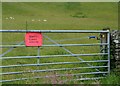
It's all right, you can come through
On the path from Wiltonburn to Borthaugh; the insulated handle enables safe passage through the electric fence. The cattle were elsewhere, but an additional hazard here was the nettle growing right next to the gate latch.
Image: © Jim Barton
Taken: 15 Jul 2012
0.21 miles
6
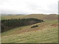
South side of Wiltonburn Hill
A sheepwalk. Looking down a blunt ridge running southwest from Wiltonburn Hill.
Image: © Richard Webb
Taken: 6 Mar 2008
0.25 miles