IMAGES TAKEN NEAR TO
Stirches Road, HAWICK, TD9 7HF
Introduction
This page details the photographs taken nearby to Stirches Road, TD9 7HF by members of the Geograph project.
The Geograph project started in 2005 with the aim of publishing, organising and preserving representative images for every square kilometre of Great Britain, Ireland and the Isle of Man.

There are currently over 7.5m images from over14,400 individuals and you can help contribute to the project by visiting https://www.geograph.org.uk
Image Map
Images are licensed for reuse under creativecommons.org/licenses/by-sa/2.0
Notes
- Clicking on the map will re-center to the selected point.
- The higher the marker number, the further away the image location is from the centre of the postcode.
Image Listing (20 Images Found)
Images are licensed for reuse under creativecommons.org/licenses/by-sa/2.0
Image
Details
Distance
1
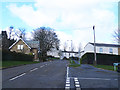
Stirches Road, Hawick
High above Hawick, a former council house area dating back to the 1970s. The road is followed by the Border Abbeys Way, a long-distance walking route through the Scottish Borders.
Image: © Oliver Dixon
Taken: 23 Mar 2014
0.03 miles
2
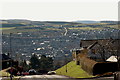
Across Hawick from Stirches
Like many textile towns, Hawick has grown around a river valley, in this case the Teviot and its tributary the Slitrig Water. The minor road in view across the valley goes through Ormiston.
Image: © Jim Barton
Taken: 23 Mar 2011
0.05 miles
3
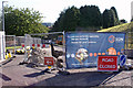
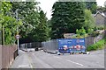
Gas main replacement, Stirches Road
The road is closed to all traffic while a gas main is replaced.
Image: © Richard Dorrell
Taken: 6 Sep 2015
0.09 miles
4
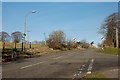
Leaving Hawick on the Borders Abbeys Way
The town limit on the climb up by Stirches Road; a Borders Abbeys Way sign can be seen on the left-hand lamppost.
Image: © Jim Barton
Taken: 23 Mar 2011
0.12 miles
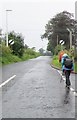
5
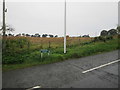
Stirches Road meets countryside
After climbing out of Hawick, the first field
Image: © Martin Dawes
Taken: 9 Sep 2019
0.13 miles
6
Road closed for gas main relaying, Hawick
Stirches Road closed to traffic here for replacing gas mains by Scottish Gas Networks. The pavement is still open for pedestrians.
Image: © Jim Barton
Taken: 13 Aug 2015
0.13 miles
7
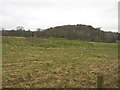
Rough grazing at Hawick
Adjacent to the Borders Abbey Way.
Image: © James Denham
Taken: 18 Apr 2010
0.13 miles
8
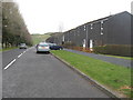
Community housing in the northern edge of Hawick
In the Scottish Borders.
Image: © James Denham
Taken: 18 Apr 2010
0.13 miles
9
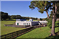
Stirches Primary School
Stirches Primary School is a co-educational, non-denominational school
providing primary education from ante pre school to P7 (Age 3-12). Current school roll is 117 pupils, with a further 23 in the Nursery department.
Image: © Richard Dorrell
Taken: 6 Sep 2015
0.15 miles
10
Stirches Road leaves Hawick
Junction of Guthrie Drive to the right
Image: © Martin Dawes
Taken: 9 Sep 2019
0.15 miles