IMAGES TAKEN NEAR TO
Bothwell Court, HAWICK, TD9 7EP
Introduction
This page details the photographs taken nearby to Bothwell Court, TD9 7EP by members of the Geograph project.
The Geograph project started in 2005 with the aim of publishing, organising and preserving representative images for every square kilometre of Great Britain, Ireland and the Isle of Man.

There are currently over 7.5m images from over14,400 individuals and you can help contribute to the project by visiting https://www.geograph.org.uk
Image Map
Images are licensed for reuse under creativecommons.org/licenses/by-sa/2.0
Notes
- Clicking on the map will re-center to the selected point.
- The higher the marker number, the further away the image location is from the centre of the postcode.
Image Listing (36 Images Found)
Images are licensed for reuse under creativecommons.org/licenses/by-sa/2.0
Image
Details
Distance
1
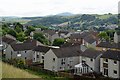
Houses at Wilton, Hawick
Houses on the NW edge of the town, looking east to the volcanic hill of Rubers Law.
Image: © Jim Barton
Taken: 15 Jul 2012
0.04 miles
2
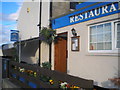
Mayfield Bar & Restaurant, Hawick
The entrance to the restaurant part of The Mayfield, in the north-west of the town.
Image: © Charlotte Lunn
Taken: 31 Jul 2010
0.07 miles
3

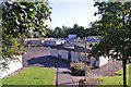
Footpath amidst the vegetation
The path, clearly not heavily used, passes to the right of the cottages and on towards Heip Hill.
Image: © Jim Barton
Taken: 15 Jul 2012
0.11 miles
4
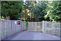
Pedestrian entrance to Wilton Primary School
Located in Wellfield Road, this suburban school has a very rural-looking pedestrian entrance.
School building: Image]
Image: © Richard Dorrell
Taken: 6 Sep 2015
0.12 miles
5
Wilton Primary School, Hawick
Located in Wellfield Road, Hawick. This building opened in 1974. The school has a current roll of 266 pupils, aged 3 - 11.
Image: © Richard Dorrell
Taken: 6 Sep 2015
0.12 miles
6
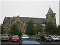
Wilton Parish Church. Hawick
Built 1860-2
Image: © Martin Dawes
Taken: 9 Sep 2019
0.13 miles
7
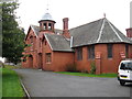
The Wilton Church Hall
At the rear of the Parish Kirk.
Image: © James Denham
Taken: 15 Mar 2012
0.13 miles
8

Top of Rosalee Brae, Hawick
The footpath towards Heip Hill continues ahead.
Image: © Jim Barton
Taken: 15 Jul 2012
0.13 miles
9
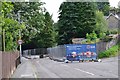
Road closed for gas main relaying, Hawick
Stirches Road closed to traffic here for replacing gas mains by Scottish Gas Networks. The pavement is still open for pedestrians.
Image: © Jim Barton
Taken: 13 Aug 2015
0.13 miles
10
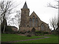
Wilton Parish Church
The magnificent building stands high above the left bank of the River Teviot at Hawick.
Image: © James Denham
Taken: 15 Mar 2012
0.14 miles