IMAGES TAKEN NEAR TO
NEWCASTLETON, TD9 0SL
Introduction
This page details the photographs taken nearby to TD9 0SL by members of the Geograph project.
The Geograph project started in 2005 with the aim of publishing, organising and preserving representative images for every square kilometre of Great Britain, Ireland and the Isle of Man.

There are currently over 7.5m images from over14,400 individuals and you can help contribute to the project by visiting https://www.geograph.org.uk
Image Map
Images are licensed for reuse under creativecommons.org/licenses/by-sa/2.0
Notes
- Clicking on the map will re-center to the selected point.
- The higher the marker number, the further away the image location is from the centre of the postcode.
Image Listing (7 Images Found)
Images are licensed for reuse under creativecommons.org/licenses/by-sa/2.0
Image
Details
Distance
1
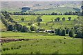
Larriston Farm
View of Larriston Farm in the valley of Liddel Water seen from beneath Bught Knowe.
Image: © Peter McDermott
Taken: 5 Jun 2010
0.01 miles
2
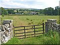
Larriston, Liddesdale
This appears to be the original gateway to the farm.
Image: © Oliver Dixon
Taken: 25 Jul 2006
0.08 miles
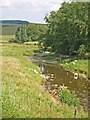
4
The Liddel Water
A view upstream from the B6357 at Larriston.
Image: © Walter Baxter
Taken: 20 Mar 2009
0.15 miles
5
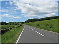
The B6357 heading towards Larriston Farm
Image: © James Denham
Taken: 15 Jun 2010
0.17 miles
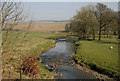
6
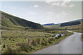
A very empty looking valley
This road is the B6357 hardly a B class road as it is really a single track road with passing places. The valley is used for sheep and cattle grazing.
Image: © Malcolm Neal
Taken: 4 May 2017
0.18 miles
7
Farm buildings at Larriston, Liddesdale
Image: © Oliver Dixon
Taken: 25 Jul 2006
0.24 miles