IMAGES TAKEN NEAR TO
NEWCASTLETON, TD9 0SA
Introduction
This page details the photographs taken nearby to TD9 0SA by members of the Geograph project.
The Geograph project started in 2005 with the aim of publishing, organising and preserving representative images for every square kilometre of Great Britain, Ireland and the Isle of Man.

There are currently over 7.5m images from over14,400 individuals and you can help contribute to the project by visiting https://www.geograph.org.uk
Image Map
Images are licensed for reuse under creativecommons.org/licenses/by-sa/2.0
Notes
- Clicking on the map will re-center to the selected point.
- The higher the marker number, the further away the image location is from the centre of the postcode.
Image Listing (6 Images Found)
Images are licensed for reuse under creativecommons.org/licenses/by-sa/2.0
Image
Details
Distance
2
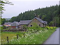
Roadside cottages
The last of the Sandholm cottages
Image: © James Denham
Taken: 2 Jun 2008
0.16 miles
3
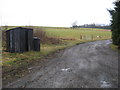
Track leading to Roan, Raltonside and Woolhope
The shed at the side doubles up as a bus shelter for the main road only yards away.
Image: © James Denham
Taken: 25 Jan 2011
0.17 miles
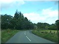
4
Roan road end
Off the B6357 north of Newcastleton.
Image: © Richard Webb
Taken: 15 May 2013
0.18 miles
5
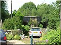
Old railway arches at Raltonburn Cottage
The arches formed part of the Waverley line from Carlisle to Edinburgh, which was built in 1862. The line was one of the most important lines to be closed by Beeching in 1969.
Image: © Oliver Dixon
Taken: 25 Jul 2006
0.19 miles
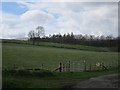
6
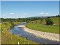
The Liddel Water
The Liddel Water north of Newcastleton.
Image: © Adrian King
Taken: 24 Jun 2009
0.24 miles