IMAGES TAKEN NEAR TO
Tweeden Brae, NEWCASTLETON, TD9 0QA
Introduction
This page details the photographs taken nearby to Tweeden Brae, TD9 0QA by members of the Geograph project.
The Geograph project started in 2005 with the aim of publishing, organising and preserving representative images for every square kilometre of Great Britain, Ireland and the Isle of Man.

There are currently over 7.5m images from over14,400 individuals and you can help contribute to the project by visiting https://www.geograph.org.uk
Image Map
Images are licensed for reuse under creativecommons.org/licenses/by-sa/2.0
Notes
- Clicking on the map will re-center to the selected point.
- The higher the marker number, the further away the image location is from the centre of the postcode.
Image Listing (5 Images Found)
Images are licensed for reuse under creativecommons.org/licenses/by-sa/2.0
Image
Details
Distance
1
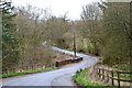
Road junction south of Newcastleton
The road from Mangerton meets the minor road from Kershope Bridge.
Image: © Jim Barton
Taken: 7 Apr 2017
0.12 miles
2
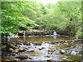
Bridge over the Tweeden Burn
The road to Newcastleton crosses the Tweeden Burn, a small tributary of the Liddel Water.
Image: © Jim Barton
Taken: 7 Apr 2017
0.17 miles
4
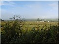
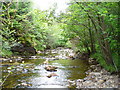
Damp pasture, Liddesdale
Morning fog lifts from Liddesdale, downstream from Newcastleton.
Image: © Richard Webb
Taken: 22 Sep 2015
0.22 miles