IMAGES TAKEN NEAR TO
HAWICK, TD9 0PW
Introduction
This page details the photographs taken nearby to TD9 0PW by members of the Geograph project.
The Geograph project started in 2005 with the aim of publishing, organising and preserving representative images for every square kilometre of Great Britain, Ireland and the Isle of Man.

There are currently over 7.5m images from over14,400 individuals and you can help contribute to the project by visiting https://www.geograph.org.uk
Image Map
Images are licensed for reuse under creativecommons.org/licenses/by-sa/2.0
Notes
- Clicking on the map will re-center to the selected point.
- The higher the marker number, the further away the image location is from the centre of the postcode.
Image Listing (5 Images Found)
Images are licensed for reuse under creativecommons.org/licenses/by-sa/2.0
Image
Details
Distance
1
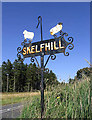
Skelfhill Farm sign
At the junction with the minor road to the farm and the A7. The farm is approximately 5km from this sign.
Image: © Walter Baxter
Taken: 7 Sep 2007
0.20 miles
3
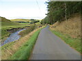
Minor road beside Northhouse Burn
Looking north-westward.
Image: © Peter Wood
Taken: 1 Oct 2021
0.22 miles
4
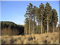
Pine trees and scrub
By the A7 opposite Mossyknowe.
Image: © Walter Baxter
Taken: 3 Feb 2007
0.22 miles
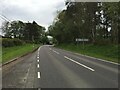
5
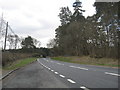
The southbound A7 at Northhouse
In the Scottish Borders.
Image: © James Denham
Taken: 20 Apr 2010
0.25 miles