IMAGES TAKEN NEAR TO
HAWICK, TD9 0PG
Introduction
This page details the photographs taken nearby to TD9 0PG by members of the Geograph project.
The Geograph project started in 2005 with the aim of publishing, organising and preserving representative images for every square kilometre of Great Britain, Ireland and the Isle of Man.

There are currently over 7.5m images from over14,400 individuals and you can help contribute to the project by visiting https://www.geograph.org.uk
Image Map
Images are licensed for reuse under creativecommons.org/licenses/by-sa/2.0
Notes
- Clicking on the map will re-center to the selected point.
- The higher the marker number, the further away the image location is from the centre of the postcode.
Image Listing (10 Images Found)
Images are licensed for reuse under creativecommons.org/licenses/by-sa/2.0
Image
Details
Distance
1
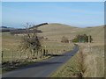
Minor road near to Dodburn Filter
Looking south-westward.
Image: © Peter Wood
Taken: 1 Oct 2021
0.06 miles
2
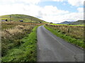
Yellow road, Dodburn
Passing Filter Beds Cottage.
Image: © Richard Webb
Taken: 14 Mar 2016
0.09 miles
3
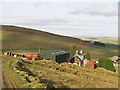
Dodburn Filter
Disused looking waterworks.
Image: © Richard Webb
Taken: 14 Mar 2016
0.17 miles
4
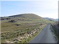
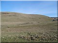
The road through Dodburn
Hills upstream of Hawick.
Image: © Richard Webb
Taken: 14 Mar 2016
0.17 miles
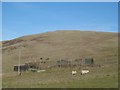
6
A sheepfold at Burgh Hill
Viewed from a minor road near Priesthaugh.
Image: © Walter Baxter
Taken: 30 Jan 2010
0.19 miles
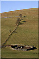
7
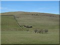
Stell, Dodburn
Classic Borders sheepfold.
Image: © Richard Webb
Taken: 14 Mar 2016
0.19 miles
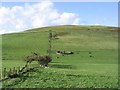
8

Three hydrant markers
These marker stones are on the east side of Burgh Hill by the minor road running up the valley of the Dod Burn midway between Priesthaugh and Dodburn.
Image: © Morley Sewell
Taken: 16 Oct 2008
0.20 miles