IMAGES TAKEN NEAR TO
HAWICK, TD9 0PD
Introduction
This page details the photographs taken nearby to TD9 0PD by members of the Geograph project.
The Geograph project started in 2005 with the aim of publishing, organising and preserving representative images for every square kilometre of Great Britain, Ireland and the Isle of Man.

There are currently over 7.5m images from over14,400 individuals and you can help contribute to the project by visiting https://www.geograph.org.uk
Image Map
Images are licensed for reuse under creativecommons.org/licenses/by-sa/2.0
Notes
- Clicking on the map will re-center to the selected point.
- The higher the marker number, the further away the image location is from the centre of the postcode.
Image Listing (8 Images Found)
Images are licensed for reuse under creativecommons.org/licenses/by-sa/2.0
Image
Details
Distance
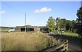
2
Cottage at Pilmuir farm
Seen from the minor road junction north of the farm.
Image: © Jim Barton
Taken: 28 Jan 2022
0.08 miles
3
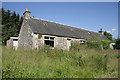
Roadside cottages at Pilmuir
These unoccupied cottages are at the edge of the square opposite Pilmuir Farm.
Image: © Walter Baxter
Taken: 14 Jul 2011
0.08 miles
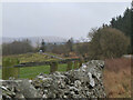
4
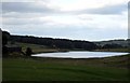
Marshy grazing lands at Pilmuir in Roxburghshire
Williestruther Loch can be seen in the background.
Image: © James Denham
Taken: 2 Sep 2012
0.08 miles
5
A view of the grazing lands of Pilmuir
With Williestruther Loch in the background. (taken with zoom)
Image: © James Denham
Taken: 2 Sep 2012
0.09 miles
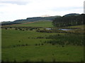
6
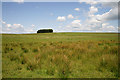
Farmland at Pilmuir
This area of hill grazing is to the west of Pilmuir Farm.
Image: © Walter Baxter
Taken: 14 Jul 2011
0.21 miles
7
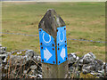
Hawick Circular Riding Route
Weatherbeaten waymarks at a road junction on the Common Riding route.
Image: © Jim Barton
Taken: 28 Jan 2022
0.21 miles
8
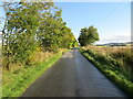
Minor road heading towards Williestruther
Looking north-eastward.
Image: © Peter Wood
Taken: 1 Oct 2021
0.24 miles