IMAGES TAKEN NEAR TO
Crumhaughhill Road, HAWICK, TD9 0NJ
Introduction
This page details the photographs taken nearby to Crumhaughhill Road, TD9 0NJ by members of the Geograph project.
The Geograph project started in 2005 with the aim of publishing, organising and preserving representative images for every square kilometre of Great Britain, Ireland and the Isle of Man.

There are currently over 7.5m images from over14,400 individuals and you can help contribute to the project by visiting https://www.geograph.org.uk
Image Map
Images are licensed for reuse under creativecommons.org/licenses/by-sa/2.0
Notes
- Clicking on the map will re-center to the selected point.
- The higher the marker number, the further away the image location is from the centre of the postcode.
Image Listing (15 Images Found)
Images are licensed for reuse under creativecommons.org/licenses/by-sa/2.0
Image
Details
Distance
1
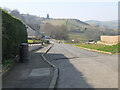
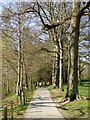
Longbaulk Road, Hawick
The end of a residential road on the SW side of the town. It continues as a track which was the old road out of Hawick.
Image: © Jim Barton
Taken: 23 Mar 2022
0.09 miles
2
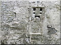
Ordnance Survey Flush Bracket 1491
This heavily over-painted bracket can be found on the wall of a private dwelling in Lynnwood.
For more detail see : http://www.bench-marks.org.uk/bm1210
Image: © Peter Wood
Taken: 13 Oct 2015
0.18 miles
3
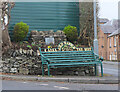
Decorative bench, Hawick
A bench with a fine view across the town, at the junction of Rosebank Road and Crumhaugh Hill Road.
Image: © Jim Barton
Taken: 28 Jan 2022
0.19 miles
4
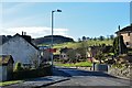
Rosebank Road, Hawick
Houses on the S edge of the town not far from the golf club.
Image: © Jim Barton
Taken: 2 Feb 2013
0.19 miles
5
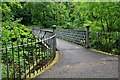
Riverside path, Wilton Lodge Park
A very attractive park by the River Teviot.
Image: © Oliver Dixon
Taken: 23 Apr 2015
0.21 miles
6
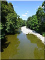
A Shallow River Teviot
Dry summer conditions have resulted in the Teviot running low. This view is from Langlands Bridge in Wilton Lodge Park.
Image: © James T M Towill
Taken: 25 Jul 2014
0.22 miles
7
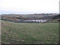
Covered reservoir
Overlooking the western edge of Hawick. Most of the town is hidden in the glen below.
Image: © Richard Webb
Taken: 6 Feb 2008
0.22 miles
8
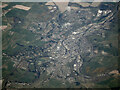
Hawick from the air
Most of the town can be seen in this view from a Glasgow bound flight from Prague at around 19,000 feet overhead. The River Teviot is the main feature, with Slitrig Water seen joining it from the lower right corner. The A7 road heading north out of the town can be seen at the top.
Image: © Thomas Nugent
Taken: 21 Apr 2022
0.22 miles
9
Langlands Bridge, Hawick
A footbridge over the Teviot in Wilton Lodge Park.
Image: © Jim Barton
Taken: 1 Jul 2012
0.22 miles
10
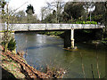
Langlands Bridge
Spans the River Teviot and provides pedestrian access to Wilton Lodge Park.
Image: © Walter Baxter
Taken: 5 Apr 2008
0.22 miles