IMAGES TAKEN NEAR TO
HAWICK, TD9 0LX
Introduction
This page details the photographs taken nearby to TD9 0LX by members of the Geograph project.
The Geograph project started in 2005 with the aim of publishing, organising and preserving representative images for every square kilometre of Great Britain, Ireland and the Isle of Man.

There are currently over 7.5m images from over14,400 individuals and you can help contribute to the project by visiting https://www.geograph.org.uk
Image Map
Images are licensed for reuse under creativecommons.org/licenses/by-sa/2.0
Notes
- Clicking on the map will re-center to the selected point.
- The higher the marker number, the further away the image location is from the centre of the postcode.
Image Listing (19 Images Found)
Images are licensed for reuse under creativecommons.org/licenses/by-sa/2.0
Image
Details
Distance
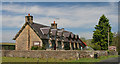
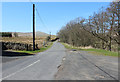
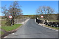
1
Road to Hermitage Castle
On the left is Hermitage Hall.
Image: © Billy McCrorie
Taken: 21 Apr 2015
0.00 miles
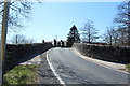
5
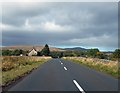
B6399 approaching Hermitage Old School House
Image: © Peter Bond
Taken: 29 Sep 2012
0.02 miles
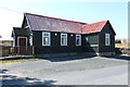
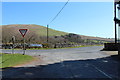
8
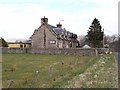
Old School House, Hermitage
At the far end of the block is a shop selling Crafts and Horn items (and a few sweeties).
Image: © Oliver Dixon
Taken: 13 Apr 2009
0.03 miles