IMAGES TAKEN NEAR TO
HAWICK, TD9 0LH
Introduction
This page details the photographs taken nearby to TD9 0LH by members of the Geograph project.
The Geograph project started in 2005 with the aim of publishing, organising and preserving representative images for every square kilometre of Great Britain, Ireland and the Isle of Man.

There are currently over 7.5m images from over14,400 individuals and you can help contribute to the project by visiting https://www.geograph.org.uk
Image Map
Images are licensed for reuse under creativecommons.org/licenses/by-sa/2.0
Notes
- Clicking on the map will re-center to the selected point.
- The higher the marker number, the further away the image location is from the centre of the postcode.
Image Listing (7 Images Found)
Images are licensed for reuse under creativecommons.org/licenses/by-sa/2.0
Image
Details
Distance
1
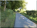
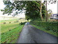
Minor road at Carlenrig
Looking north-eastward.
Image: © Peter Wood
Taken: 1 Oct 2021
0.02 miles
2
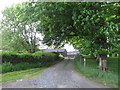
Carlenrig Farm near Teviothead
Track to the farmyard.
Image: © James Denham
Taken: 28 May 2010
0.04 miles
3
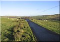
A country road
A single track road with passing places that runs for approximately 6km from Teviothead to Merrylaw at the edge of Craik Forest.
Image: © Walter Baxter
Taken: 17 Dec 2006
0.08 miles
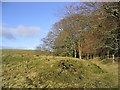
5
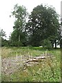
Replanted woodland, Woodbrae
A small wood at Teviothead.
Image: © Richard Webb
Taken: 27 Aug 2009
0.09 miles
6
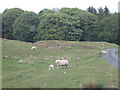
What's that, mum?
"A fool out taking photographs in the rain, Dimple." View from a minor road approaching Carlenrig.http://www.fw.ipsos.com/wix/p0093933.aspx
Image: © James Denham
Taken: 28 May 2010
0.11 miles
7
Minor road near to Woodbrae
Looking north-eastward.
Image: © Peter Wood
Taken: 1 Oct 2021
0.13 miles