IMAGES TAKEN NEAR TO
HAWICK, TD9 0LF
Introduction
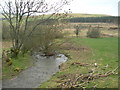
This page details the photographs taken nearby to TD9 0LF by members of the Geograph project.
The Geograph project started in 2005 with the aim of publishing, organising and preserving representative images for every square kilometre of Great Britain, Ireland and the Isle of Man.

There are currently over 7.5m images from over14,400 individuals and you can help contribute to the project by visiting https://www.geograph.org.uk
Image Map
Images are licensed for reuse under creativecommons.org/licenses/by-sa/2.0
Notes
- Clicking on the map will re-center to the selected point.
- The higher the marker number, the further away the image location is from the centre of the postcode.
Image Listing (2 Images Found)
Images are licensed for reuse under creativecommons.org/licenses/by-sa/2.0
Image
Details
Distance
2
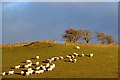
Farmland at Colterscleuch
The sheep in this field on the southeast side of the A7 are highlighted by late afternoon December sunshine.
Image: © Walter Baxter
Taken: 9 Dec 2012
0.22 miles