IMAGES TAKEN NEAR TO
Crumhaughhill Road, HAWICK, TD9 0BX
Introduction
This page details the photographs taken nearby to Crumhaughhill Road, TD9 0BX by members of the Geograph project.
The Geograph project started in 2005 with the aim of publishing, organising and preserving representative images for every square kilometre of Great Britain, Ireland and the Isle of Man.

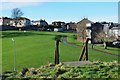
There are currently over 7.5m images from over14,400 individuals and you can help contribute to the project by visiting https://www.geograph.org.uk
Image Map
Images are licensed for reuse under creativecommons.org/licenses/by-sa/2.0
Notes
- Clicking on the map will re-center to the selected point.
- The higher the marker number, the further away the image location is from the centre of the postcode.
Image Listing (12 Images Found)
Images are licensed for reuse under creativecommons.org/licenses/by-sa/2.0
Image
Details
Distance
1
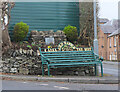
Decorative bench, Hawick
A bench with a fine view across the town, at the junction of Rosebank Road and Crumhaugh Hill Road.
Image: © Jim Barton
Taken: 28 Jan 2022
0.11 miles
2
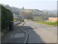
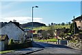
Longbaulk Road, Hawick
The end of a residential road on the SW side of the town. It continues as a track which was the old road out of Hawick.
Image: © Jim Barton
Taken: 23 Mar 2022
0.16 miles
3
Cheviot Road, Hawick
Looking north-westward.
Image: © Peter Wood
Taken: 1 Oct 2021
0.18 miles
4
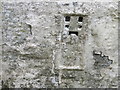
Ordnance Survey Flush Bracket 1491
This heavily over-painted bracket can be found on the wall of a private dwelling in Lynnwood.
For more detail see : http://www.bench-marks.org.uk/bm1210
Image: © Peter Wood
Taken: 13 Oct 2015
0.20 miles
5
From the top of Hawick Motte
Green space and housing by the park with the top of the steps in the foreground.
Image: © Jim Barton
Taken: 2 Feb 2013
0.21 miles
6
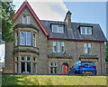
Balcary House
Hawick: built in 1888 for the prosperous Laing family - local millowners - it was purchased by Barnardos during the last War as a refuge for children evacuated from Kent, and continued as a foster home for a further thirty years.
In 2015, it reopened as a luxury hotel.
Image: © Anthony O'Neil
Taken: 21 Jun 2023
0.21 miles
7
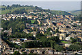
Hawick in the Scottish Borders
This is a view to the southwest end of Hawick towards Crumhaugh Hill from Miller’s Knowes on the southeast side of the town. Hawick sits in the valley of the River Teviot and is the largest town in the Scottish Borders. The town is famous for textiles although this industry has been in decline for several years.
Image: © Walter Baxter
Taken: 21 Sep 2008
0.21 miles
8
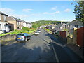
Rosebank Road, Hawick
Houses on the S edge of the town not far from the golf club.
Image: © Jim Barton
Taken: 2 Feb 2013
0.22 miles
9
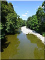
A Shallow River Teviot
Dry summer conditions have resulted in the Teviot running low. This view is from Langlands Bridge in Wilton Lodge Park.
Image: © James T M Towill
Taken: 25 Jul 2014
0.25 miles
10
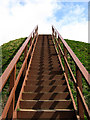
The steps up Hawick Motte
These timber steps provide access up to the top of the 8m high mound Image
Image: © Walter Baxter
Taken: 16 Apr 2008
0.25 miles