IMAGES TAKEN NEAR TO
Ancrum, JEDBURGH, TD8 6UP
Introduction
This page details the photographs taken nearby to TD8 6UP by members of the Geograph project.
The Geograph project started in 2005 with the aim of publishing, organising and preserving representative images for every square kilometre of Great Britain, Ireland and the Isle of Man.

There are currently over 7.5m images from over14,400 individuals and you can help contribute to the project by visiting https://www.geograph.org.uk
Image Map
Images are licensed for reuse under creativecommons.org/licenses/by-sa/2.0
Notes
- Clicking on the map will re-center to the selected point.
- The higher the marker number, the further away the image location is from the centre of the postcode.
Image Listing (15 Images Found)
Images are licensed for reuse under creativecommons.org/licenses/by-sa/2.0
Image
Details
Distance
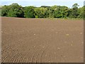
1
Williamrig, in the valley of the Ale Water
Looking across a newly sown cereal field.
Image: © M J Richardson
Taken: 3 Oct 2009
0.01 miles
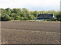
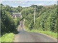
2
Spring barley, Williamrig
Beside the Ale Water.
Image: © Richard Webb
Taken: 17 Jul 2024
0.04 miles
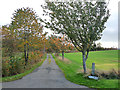
4
Looking towards the bridge over the Ale Water at Sandystones
The lane north from Pinnacle and the B6400.
Image: © M J Richardson
Taken: 3 Oct 2009
0.05 miles
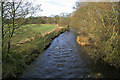
5
The Ale Water near Sandystones
In the Scottish Borders.
Image: © James Denham
Taken: 17 Apr 2010
0.07 miles
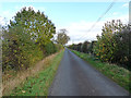
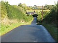
6
Road, Sandystones
Descent to a bridge over the Ale Water.
Image: © Richard Webb
Taken: 17 Jul 2024
0.08 miles
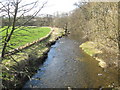
7
The Ale Water
Viewed from a bridge near Sandystones Farm.
Image: © Walter Baxter
Taken: 12 Nov 2008
0.11 miles
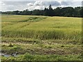
8
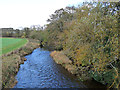
The Ale Water at Sandystones
Looking upstream.
Image: © Oliver Dixon
Taken: 24 Oct 2014
0.12 miles