IMAGES TAKEN NEAR TO
JEDBURGH, TD8 6UG
Introduction
This page details the photographs taken nearby to TD8 6UG by members of the Geograph project.
The Geograph project started in 2005 with the aim of publishing, organising and preserving representative images for every square kilometre of Great Britain, Ireland and the Isle of Man.

There are currently over 7.5m images from over14,400 individuals and you can help contribute to the project by visiting https://www.geograph.org.uk
Image Map
Images are licensed for reuse under creativecommons.org/licenses/by-sa/2.0
Notes
- Clicking on the map will re-center to the selected point.
- The higher the marker number, the further away the image location is from the centre of the postcode.
Image Listing (46 Images Found)
Images are licensed for reuse under creativecommons.org/licenses/by-sa/2.0
Image
Details
Distance
1
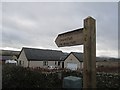
Path sign, Ancrum
Scottish Borders Council core path no. 104.
Image: © Richard Webb
Taken: 14 Feb 2013
0.07 miles
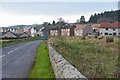
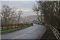
2
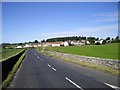
Ancrum
Looking west along the B6400 towards the village.
Image: © Callum Black
Taken: 23 Jun 2009
0.08 miles
3
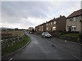
South Myrescroft
Residential road in Ancrum.
Image: © Richard Webb
Taken: 14 Feb 2013
0.10 miles
4
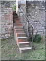
Stone steps at Ale Bridge, Ancrum
These steps provide access to a walking route beside the Ale Water
Image: © Walter Baxter
Taken: 12 Sep 2006
0.10 miles
5
Ancrum from the east
New houses (L) on the southern side of the village close to the A68.
Image: © Jim Barton
Taken: 31 Oct 2014
0.11 miles
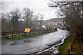
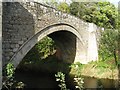
7
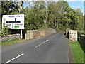
Bridge over the Ale Water
Carrying the B6400 from Ancrum to the A68.
Image: © M J Richardson
Taken: 3 Oct 2009
0.11 miles
9
Single arched bridge over the Ale Water
Image: © M J Richardson
Taken: 3 Oct 2009
0.12 miles