IMAGES TAKEN NEAR TO
JEDBURGH, TD8 6TX
Introduction
This page details the photographs taken nearby to TD8 6TX by members of the Geograph project.
The Geograph project started in 2005 with the aim of publishing, organising and preserving representative images for every square kilometre of Great Britain, Ireland and the Isle of Man.

There are currently over 7.5m images from over14,400 individuals and you can help contribute to the project by visiting https://www.geograph.org.uk
Image Map
Images are licensed for reuse under creativecommons.org/licenses/by-sa/2.0
Notes
- Clicking on the map will re-center to the selected point.
- The higher the marker number, the further away the image location is from the centre of the postcode.
Image Listing (6 Images Found)
Images are licensed for reuse under creativecommons.org/licenses/by-sa/2.0
Image
Details
Distance
1
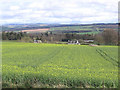
Rapeseed field at Howden
Viewed from a minor road with the Cheviot Hills in the distance.
Image: © Walter Baxter
Taken: 9 Apr 2007
0.11 miles
2
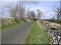
Country Road
A narrow road to the northeast of Ancrum.
Image: © Walter Baxter
Taken: 9 Apr 2007
0.22 miles
3
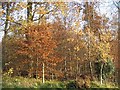
Woods near Howden
Beech woods at the end of Autumn.
Image: © Richard Webb
Taken: 16 Nov 2008
0.23 miles
5
Minor road north from B6400
Close to the Harestanes estate this minor road leaves the B6400; it's unclear whether it's a public one or a private estate road but there's no notice denying access over it.
Image: © Trevor Littlewood
Taken: 31 Oct 2010
0.24 miles
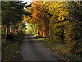
6
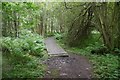
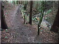
Boardwalk, Divet Ha' Wood
St Cuthbert's Way at a muddy bit.
Image: © Richard Webb
Taken: 21 Aug 2016
0.24 miles