IMAGES TAKEN NEAR TO
JEDBURGH, TD8 6TS
Introduction
This page details the photographs taken nearby to TD8 6TS by members of the Geograph project.
The Geograph project started in 2005 with the aim of publishing, organising and preserving representative images for every square kilometre of Great Britain, Ireland and the Isle of Man.

There are currently over 7.5m images from over14,400 individuals and you can help contribute to the project by visiting https://www.geograph.org.uk
Image Map
Images are licensed for reuse under creativecommons.org/licenses/by-sa/2.0
Notes
- Clicking on the map will re-center to the selected point.
- The higher the marker number, the further away the image location is from the centre of the postcode.
Image Listing (31 Images Found)
Images are licensed for reuse under creativecommons.org/licenses/by-sa/2.0
Image
Details
Distance
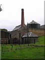
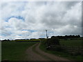
2
East Nisbet farm
Substantial farm buildings by the minor road NE of the village.
Image: © Jim Barton
Taken: 5 Aug 2018
0.05 miles
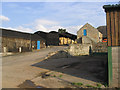

6
Track in to the fields at East Nisbet Farm
Image: © James Denham
Taken: 22 May 2009
0.08 miles
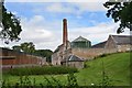
7
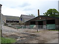
East Nisbet Farm
The farm looks so clean and empty, almost as if it wasn't working to capacity, like many other farms.
Image: © James Denham
Taken: 22 May 2009
0.08 miles

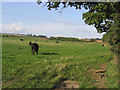
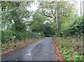
10

Grazing, East Nisbet
On a dreich day (hence lack of light and colour).
Image: © JThomas
Taken: 12 Oct 2021
0.12 miles