IMAGES TAKEN NEAR TO
JEDBURGH, TD8 6TF
Introduction
This page details the photographs taken nearby to TD8 6TF by members of the Geograph project.
The Geograph project started in 2005 with the aim of publishing, organising and preserving representative images for every square kilometre of Great Britain, Ireland and the Isle of Man.

There are currently over 7.5m images from over14,400 individuals and you can help contribute to the project by visiting https://www.geograph.org.uk
Image Map
Images are licensed for reuse under creativecommons.org/licenses/by-sa/2.0
Notes
- Clicking on the map will re-center to the selected point.
- The higher the marker number, the further away the image location is from the centre of the postcode.
Image Listing (5 Images Found)
Images are licensed for reuse under creativecommons.org/licenses/by-sa/2.0
Image
Details
Distance
1
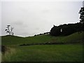
Wester Ulston Farm
Looking across a field of wheat towards this farm on the eastern slopes of the Jed Water valley.
Image: © Oliver Dixon
Taken: 2 Aug 2012
0.04 miles
2
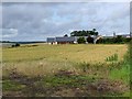
Field edge view at Wester Ulston Triangulation Pillar
Looking north-eastward.
Image: © Peter Wood
Taken: 11 Oct 2015
0.19 miles
3
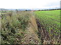
Farm Entrance (Spot the Road Surface!)
Wester Ulston farm. Unclassified Jedburgh to Crailing road.
Image: © Irvine Smith
Taken: 13 Dec 2005
0.22 miles
4
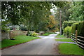
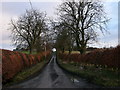
Road through Easter Ulston
Well-kept verges in front of several houses, some fairly new, around the farm of Easter Ulston.
Image: © Jim Barton
Taken: 23 Sep 2011
0.22 miles