IMAGES TAKEN NEAR TO
JEDBURGH, TD8 6SQ
Introduction
This page details the photographs taken nearby to TD8 6SQ by members of the Geograph project.
The Geograph project started in 2005 with the aim of publishing, organising and preserving representative images for every square kilometre of Great Britain, Ireland and the Isle of Man.

There are currently over 7.5m images from over14,400 individuals and you can help contribute to the project by visiting https://www.geograph.org.uk
Image Map
Images are licensed for reuse under creativecommons.org/licenses/by-sa/2.0
Notes
- Clicking on the map will re-center to the selected point.
- The higher the marker number, the further away the image location is from the centre of the postcode.
Image Listing (5 Images Found)
Images are licensed for reuse under creativecommons.org/licenses/by-sa/2.0
Image
Details
Distance
1
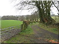
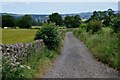
Track at Sharplaw
Leading to Bonjedward House.
Image: © M J Richardson
Taken: 6 Apr 2012
0.21 miles
2
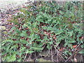
Polypody fern (Polypodium vulgare)
Growing at the base of a trackside tree in Teviotdale. It often grows on mossy rocks and as an epiphyte on tree branches.
Image: © M J Richardson
Taken: 6 Apr 2012
0.21 miles
3
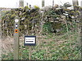
Footpath signs near Bonjedward
Jedforest Trails, Justice Trail, the Lanton Loop, and the track to Williescrook Pottery Studio.
Image: © M J Richardson
Taken: 6 Apr 2012
0.22 miles
4
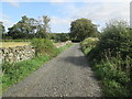
Track to Sharplaw Road from Lanton Moor
Image: © Martin Dawes
Taken: 13 Sep 2019
0.22 miles
5
Lane to Williescrook
The lane for access to Williescrook cottage and Lanton Moor woodland from the minor road near Monklaw.
Image: © Jim Barton
Taken: 25 Jul 2012
0.23 miles