IMAGES TAKEN NEAR TO
JEDBURGH, TD8 6SP
Introduction
This page details the photographs taken nearby to TD8 6SP by members of the Geograph project.
The Geograph project started in 2005 with the aim of publishing, organising and preserving representative images for every square kilometre of Great Britain, Ireland and the Isle of Man.

There are currently over 7.5m images from over14,400 individuals and you can help contribute to the project by visiting https://www.geograph.org.uk
Image Map
Images are licensed for reuse under creativecommons.org/licenses/by-sa/2.0
Notes
- Clicking on the map will re-center to the selected point.
- The higher the marker number, the further away the image location is from the centre of the postcode.
Image Listing (3 Images Found)
Images are licensed for reuse under creativecommons.org/licenses/by-sa/2.0
Image
Details
Distance
1
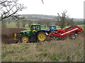
Preparing for potatoes
A Grimme CW150 stone separator at Bonjedward.
Image: © M J Richardson
Taken: 6 Apr 2012
0.18 miles
2
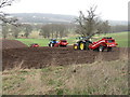
Energy intensive potato production
There were eight smart tractors working in this field of about 5.5 ha, preparing it for potato planting; three or four working stone separators, one with the trailer of potato boxes, and others ready to do I'm not sure what. The River Teviot is about 0.8 km to the left.
Image: © M J Richardson
Taken: 6 Apr 2012
0.25 miles
3
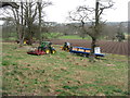
Preparing for potato planting
Disc harrow and other cultivation tools, and potato boxes containing the 'seed'.
Image: © M J Richardson
Taken: 6 Apr 2012
0.25 miles