IMAGES TAKEN NEAR TO
JEDBURGH, TD8 6RP
Introduction
This page details the photographs taken nearby to TD8 6RP by members of the Geograph project.
The Geograph project started in 2005 with the aim of publishing, organising and preserving representative images for every square kilometre of Great Britain, Ireland and the Isle of Man.

There are currently over 7.5m images from over14,400 individuals and you can help contribute to the project by visiting https://www.geograph.org.uk
Image Map
Images are licensed for reuse under creativecommons.org/licenses/by-sa/2.0
Notes
- Clicking on the map will re-center to the selected point.
- The higher the marker number, the further away the image location is from the centre of the postcode.
Image Listing (9 Images Found)
Images are licensed for reuse under creativecommons.org/licenses/by-sa/2.0
Image
Details
Distance
1
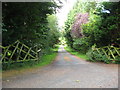
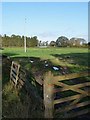
Entrance to Rennieston Estate near Oxnam
In the Scottish Borders.
Image: © James Denham
Taken: 26 Aug 2012
0.05 miles
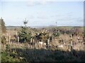
3
Barley, Rennieston
There is a galvanised drinking trough here, showing the change in land use.
Image: © Richard Webb
Taken: 27 Aug 2013
0.14 miles
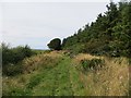
4

Track following the line of an old Roman Road (Dere Street)
Looking north-westward.
Image: © Peter Wood
Taken: 13 Dec 2018
0.14 miles
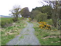
5
Dere Street
Unsealed section of the Roman road. This length has a good surface beneath the grass but it becomes rutted and muddy a few hundred metres to the northwest.
Image: © Richard Webb
Taken: 27 Aug 2013
0.15 miles
6
Single wind turbine at Rennieston
Not forming part of a larger windfarm, this wind turbine is presumably constructed to serve the nearby farm.
Image: © Oliver Dixon
Taken: 27 Oct 2010
0.15 miles
7
Dere Street - north-west
Here the Roman Road proceeds in a straight line as a green lane to cross the Teviot by Monteviot House. Dere Street was constructed in the late 1st century AD to link the legionary fortress of York (Eburacum) and Inchtuthil, near Perth. Long after the Romans had withdrawn from Britain, this remained the principal north-south route for medieval armies, such as the 6th century warriors of the Gododdin and the armies of Edward I in the Wars of Independence.
Image: © Jonathan Billinger
Taken: 19 Apr 2007
0.17 miles
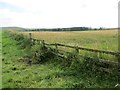
8
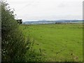
Farmland near Rennieston
Inside the southwest quadrant of a crossroads.
Image: © Richard Webb
Taken: 27 Aug 2013
0.18 miles
9
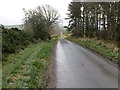
Minor road at Shotheids that follows the line of an old Roman Road (Dere Street)
Looking south-eastward.
Image: © Peter Wood
Taken: 13 Dec 2018
0.20 miles