IMAGES TAKEN NEAR TO
JEDBURGH, TD8 6QP
Introduction
This page details the photographs taken nearby to TD8 6QP by members of the Geograph project.
The Geograph project started in 2005 with the aim of publishing, organising and preserving representative images for every square kilometre of Great Britain, Ireland and the Isle of Man.

There are currently over 7.5m images from over14,400 individuals and you can help contribute to the project by visiting https://www.geograph.org.uk
Image Map
Images are licensed for reuse under creativecommons.org/licenses/by-sa/2.0
Notes
- Clicking on the map will re-center to the selected point.
- The higher the marker number, the further away the image location is from the centre of the postcode.
Image Listing (7 Images Found)
Images are licensed for reuse under creativecommons.org/licenses/by-sa/2.0
Image
Details
Distance
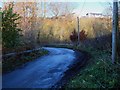
1
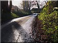
On the road near Howden farm
The country lane to Scraesburgh on the E side of Jedburgh on a November morning.
Image: © Jim Barton
Taken: 18 Nov 2012
0.05 miles
3
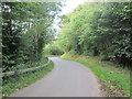
Minor road dropping down to Jedburgh
No footpaths got to walk the tarmac
Image: © Martin Dawes
Taken: 14 Sep 2019
0.12 miles
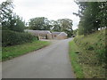
4
Bends down to the bridge over Howden Burn
Image: © Martin Dawes
Taken: 14 Sep 2019
0.15 miles
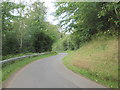
5
Minor road near Howden Burn, Jedburgh
The road to Scraesburgh crossing the Howdenburn Glen on the E side of the town.
Image: © Jim Barton
Taken: 18 Nov 2012
0.16 miles
6
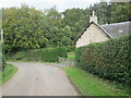
Lane and Coach House
The footpath from Hunthill through the woods comes out on to the lane here
Image: © Martin Dawes
Taken: 14 Sep 2019
0.18 miles
7
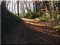
Woodland path, Howden
The path goes to the drive at Hunthill and is part of the Jedburgh East Circular walk.
Image: © Jim Barton
Taken: 18 Nov 2012
0.21 miles