IMAGES TAKEN NEAR TO
JEDBURGH, TD8 6PU
Introduction
This page details the photographs taken nearby to TD8 6PU by members of the Geograph project.
The Geograph project started in 2005 with the aim of publishing, organising and preserving representative images for every square kilometre of Great Britain, Ireland and the Isle of Man.

There are currently over 7.5m images from over14,400 individuals and you can help contribute to the project by visiting https://www.geograph.org.uk
Image Map
Images are licensed for reuse under creativecommons.org/licenses/by-sa/2.0
Notes
- Clicking on the map will re-center to the selected point.
- The higher the marker number, the further away the image location is from the centre of the postcode.
Image Listing (6 Images Found)
Images are licensed for reuse under creativecommons.org/licenses/by-sa/2.0
Image
Details
Distance
1
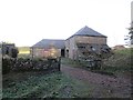
Steading, Arks
Arks was for sale at the time for offers over £250000.
Image: © Richard Webb
Taken: 20 Dec 2014
0.01 miles
2
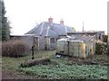
Arks
A house on the forest edge, for sale at offers over £250,000 along with 4Ha of land.
Image: © Richard Webb
Taken: 20 Dec 2014
0.03 miles
3
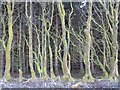
Old beech hedge
Now half revealed by a clear fell, a grown out beech hedge from before the planting of conifers behind Arks.
Image: © Richard Webb
Taken: 20 Dec 2014
0.09 miles
4
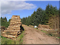
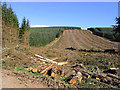
Log stacks in Leithope Forest
Adjacent to a large clear fell area.
Image: © Walter Baxter
Taken: 24 Aug 2007
0.14 miles
5
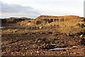
Borrow pit, Leithope Forest
An active roadstone quarry.
Image: © Richard Webb
Taken: 20 Dec 2014
0.16 miles