IMAGES TAKEN NEAR TO
JEDBURGH, TD8 6PR
Introduction
This page details the photographs taken nearby to TD8 6PR by members of the Geograph project.
The Geograph project started in 2005 with the aim of publishing, organising and preserving representative images for every square kilometre of Great Britain, Ireland and the Isle of Man.

There are currently over 7.5m images from over14,400 individuals and you can help contribute to the project by visiting https://www.geograph.org.uk
Image Map
Images are licensed for reuse under creativecommons.org/licenses/by-sa/2.0
Notes
- Clicking on the map will re-center to the selected point.
- The higher the marker number, the further away the image location is from the centre of the postcode.
Image Listing (15 Images Found)
Images are licensed for reuse under creativecommons.org/licenses/by-sa/2.0
Image
Details
Distance
1

Ordnance Survey Cut Mark
This OS cut mark can be found on the south angle of Hass House. It marks a point 245.769m above mean sea level.
Image: © Adrian Dust
Taken: 7 Oct 2015
0.05 miles
2
Junction of Lethem road and the A68
At Haas.
Image: © James Denham
Taken: 16 Jun 2010
0.06 miles
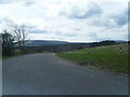
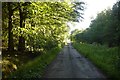
4
Road to the Hass Lochs
Descends steeply towards a fishery.
Image: © Richard Webb
Taken: 24 Jun 2018
0.10 miles
6
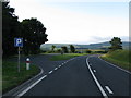
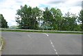
Lay-by on the A68
Looking south along the A68 towards the Carter Bar which can be seen in the distance.
Image: © G Laird
Taken: 20 Jul 2009
0.13 miles
7
Cottages at Carter View off the A68 south of Jedburgh
Image: © James Denham
Taken: 6 Aug 2012
0.13 miles
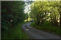
8
Road, Hass
Through mainly forested land between the A68 and A6088.
Image: © Richard Webb
Taken: 24 Jun 2018
0.15 miles
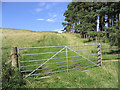
9
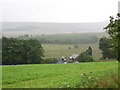
Field and A68, Hass
A dolerite outcrop running for a long distance north of the Cheviots has been quarried here. The nearby hill is split by a quarry at the summit.
Image: © Richard Webb
Taken: 9 Jan 2023
0.19 miles
10
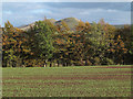
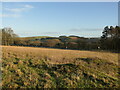
Planted field east of A68
A sprouting crop shows in the field beyond which is a shelter belt of trees; the hills showing are Goshen Hill and Philip Law, lower tops of the Cheviot range.
Image: © Trevor Littlewood
Taken: 26 Oct 2012
0.19 miles