IMAGES TAKEN NEAR TO
JEDBURGH, TD8 6PF
Introduction
This page details the photographs taken nearby to TD8 6PF by members of the Geograph project.
The Geograph project started in 2005 with the aim of publishing, organising and preserving representative images for every square kilometre of Great Britain, Ireland and the Isle of Man.

There are currently over 7.5m images from over14,400 individuals and you can help contribute to the project by visiting https://www.geograph.org.uk
Image Map
Images are licensed for reuse under creativecommons.org/licenses/by-sa/2.0
Notes
- Clicking on the map will re-center to the selected point.
- The higher the marker number, the further away the image location is from the centre of the postcode.
Image Listing (10 Images Found)
Images are licensed for reuse under creativecommons.org/licenses/by-sa/2.0
Image
Details
Distance
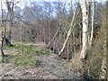
1

Path above Deep Cleuch
School Wood, Glendouglas.
Image: © Richard Webb
Taken: 16 Mar 2014
0.05 miles
2
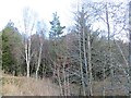
School Wood
Named after the now closed school at Glendouglas.
Image: © Richard Webb
Taken: 16 Mar 2014
0.06 miles
3
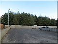
Car park, Glendouglas Community Hall
The community hall was built in 2000. The wood is called School Wood, and there was a school near here until quite recently.
Image: © Richard Webb
Taken: 16 Mar 2014
0.08 miles
4
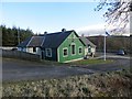
Glendouglas Community Hall
Built in 2000.
Image: © Richard Webb
Taken: 16 Mar 2014
0.09 miles
5
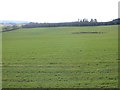
Arable land, Glendouglas
Winter cereals, south of the community hall.
Image: © Richard Webb
Taken: 16 Mar 2014
0.11 miles
6
Woods, Deep Cleuch
The ground drops away sharply here to a burn.
Image: © Richard Webb
Taken: 16 Mar 2014
0.12 miles
7
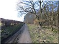
Road to Gilliestongues
A long farm drive beside Deep Cleuch.
Image: © Richard Webb
Taken: 16 Mar 2014
0.12 miles
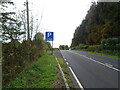
9
A road going nowhere
A curious stretch of road! It's broad as it leaves the A68 to the west but it ends within perhaps 30 metres of the junction and the height of the kerbstones and roughness of surface shows that no 'black top' has been applied. Beyond the road end a slope descends so steeply towards the Jed Water that is seems unlikely that it would continue directly in that direction.
Image: © Trevor Littlewood
Taken: 19 May 2018
0.17 miles
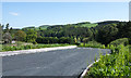
10
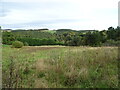
Rough grazing land and woodland
Looking down from the A68 towards the Jed Water.
Image: © JThomas
Taken: 11 Oct 2021
0.20 miles