IMAGES TAKEN NEAR TO
JEDBURGH, TD8 6PB
Introduction
This page details the photographs taken nearby to TD8 6PB by members of the Geograph project.
The Geograph project started in 2005 with the aim of publishing, organising and preserving representative images for every square kilometre of Great Britain, Ireland and the Isle of Man.

There are currently over 7.5m images from over14,400 individuals and you can help contribute to the project by visiting https://www.geograph.org.uk
Image Map
Images are licensed for reuse under creativecommons.org/licenses/by-sa/2.0
Notes
- Clicking on the map will re-center to the selected point.
- The higher the marker number, the further away the image location is from the centre of the postcode.
Image Listing (7 Images Found)
Images are licensed for reuse under creativecommons.org/licenses/by-sa/2.0
Image
Details
Distance
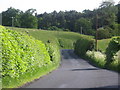
1
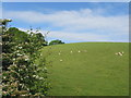
Grazing land near Langlee
South of Jedburgh.
Image: © James Denham
Taken: 15 Jun 2010
0.13 miles
3
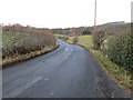
Road (B6357) near Lintalee
Looking north-eastward towards the A68.
Image: © Peter Wood
Taken: 13 Dec 2018
0.14 miles
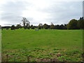
4
Hedges and oil drums
The A68 runs between the two hedge lines. The oil drums appear to be part of a jump for horses - there are other similar things in the field.
Image: © Trevor Littlewood
Taken: 22 Apr 2017
0.17 miles
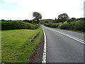
6
The B6457 heading for the A68 near Langlee
South of Jedburgh.
Image: © James Denham
Taken: 15 Jun 2010
0.18 miles
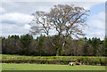
7
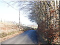
B6357
The wooded ground on the right drops steeply to the Standalane Burn.
Image: © Richard Webb
Taken: 13 Feb 2023
0.21 miles